Cross Section
C Opening of the Proto-Atlantic (Iapetan) Ocean Earliest Cambrian; 570 - 560 mya 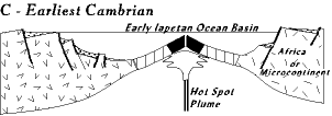 Geologically this stage and the next are short; 5-10 million years. The horsts and graben are fully developed with shear, towering cliffs plunging abruptly into deep, long valleys. Some of the rift valleys are dry, except for lakes trapped in the graben, but others have filled with sea water. Earthquakes are numerous, and sometimes very strong. And evidence of volcanic activity is everywhere. Plus, if we extrapolate from modern rifts, there were volcanoes of many sizes, and lava flows everywhere. And geysers and hot springs that sometimes turned the lakes into salt brines or hell-holes of caustic sodas. Quite likely some of the lakes are brighlty colored reds, oranges, blues, purples of communities of extremophile bacteria. These extremophile bacteria, representing the oldest life forms on earth, have been living around volcanos and gysers for billions of years, as they still do today. 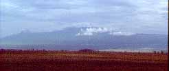 Rifting events are always accompanied by volcanic activity, and in Virginia this volcanic activity lasted a couple of hundred million years, a long span of time by most rifting standards. It includes the Crossnore Event and the Catoctin formation. The Crossnore event is represented by thousands of feet of rhyolite volcanic deposits in the Mt. Rodgers region of south-central Virgina (south end of the Blue Rdige province) and at South Mountain in southeastern Pennsylvania, and the Robertson River granite in the northern Virginia Blue Ridge Province. The Crossnore event must have produced towering volcanos evidenced by the thousands of feet of lava and pyroclastics. The picture, for example, is of Mt. Kilimanjaro in East Africa, a volcano in the center of a hotspt. The Mt. Rogers and South Mountain volcanos very likely were like this, but their relation to the Proto-Atlantic rifting is not clear yet; it is further described in the links at the bottom.
The relationship of the Catoctin formation to the rifting event is more clear. The Catoctin is about 2000 feet of basaltic lava flows, some now well exposed along I64 at Afton mountain west of Charlottesville, and along Skyline Drive south of the Little Stony Man overlook. It also underlies Monticello, Thomas Jefferson's home on the southeast flank of the Blue Ridge anticline. The initiation of oceanic lithosphere begins with a surge of volcanic activity to produce "transition crust" (sretched and thinned continental granite massively injected with basaltic dikes). The volcanic activity is always located on one side of a rift valley or the other; axial rifts do not typically split down the middle. Compare the first two rift cross sections before the ocean begins to form with the third. Notice that the axial rift in the third cross section has remained with the western (left side) continent, like it did in the Proto-Atlantic rifting. Also notice the "transition crust" in the third cross section. Here the Proto-Atlantic oceanic lithosphere begins to form. We would, of course, like to visit and see this transition crust but what remains of it is now deeply buried in the subsurface under the eastern piedmont. We know it exists only because geophysical probing (gravity and seismic [earthquake] studies) indicate it is down there. 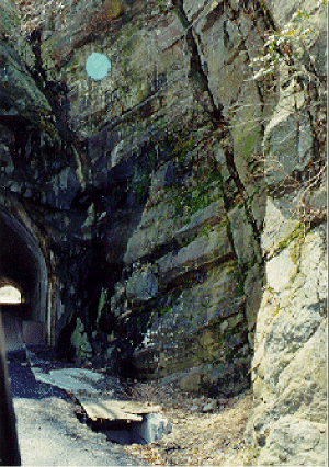 The Catoctin formation preserved in the Blue Ridge is not the remains of the injected oceanic lithosphere but rather related lava flows spilled out onto the surface of the horsts and grabens by feeder dikes that reached the surface. Many such dikes, preserved in the Blue Ridge, criss-cross the region. For example, the feeder dike at the north entrance to Mary's Rock tunnel just south of the Thornton Gap entrance to Skyline Drive (click picture for description). The Catoctin formation preserved in the Blue Ridge is not the remains of the injected oceanic lithosphere but rather related lava flows spilled out onto the surface of the horsts and grabens by feeder dikes that reached the surface. Many such dikes, preserved in the Blue Ridge, criss-cross the region. For example, the feeder dike at the north entrance to Mary's Rock tunnel just south of the Thornton Gap entrance to Skyline Drive (click picture for description). Remains of the lava flows are now found on both flanks of the Blue Ridge anticline. The ones on the northwest have evidence of forming on land, but the southeast ones are often pillow basalts, indicating formation under water (subaqueous). The southeast pillow basalt flows likely were extruded in the sea water filling the axial rift. In the southeast flank the Lynchburg group of formations (little left of center in the drawing) are sediments deposited in the axial rift in alluvial and submarine fans; note the Catoctin lies on top of them in places. By its position in the rock sequence the Catoctin allows us to date the initiation of ocean formation. In many places the lava flows lie directly on exposed Grenville batholiths in an unconformity nearly half a billion years old; these are likely the horst blocks raised by the rifting process (Catoctin under name Chilhowee in the center of the NW flank is on basement). In other places the lava flows cover the Swift Run formation, sandstones and shales deposited in the low lying areas, perhaps graben valleys (NW flank). All in all the evidence indicates a rugged topography slowly buried by lava flow after lava flow. 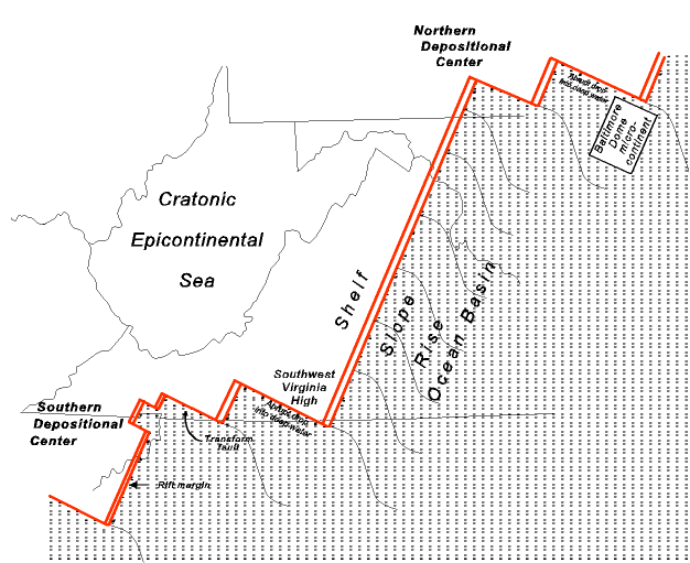 Initially we like to think of things simply, and our first thought is that the rifting event created a relatively smooth coastline. But this is not the case. The shape of the continental margin resulting from the rifting is shown in the paleogeographic map (click for large version). Note how irregular the coast line is (marked in red). The double red lines are rifted margins, and the single lines at right angles to them are transform faults. This jagged coast line with its promotories and reentrants will play important rolls in future events. Initially we like to think of things simply, and our first thought is that the rifting event created a relatively smooth coastline. But this is not the case. The shape of the continental margin resulting from the rifting is shown in the paleogeographic map (click for large version). Note how irregular the coast line is (marked in red). The double red lines are rifted margins, and the single lines at right angles to them are transform faults. This jagged coast line with its promotories and reentrants will play important rolls in future events.It is clear from this map that nothing east of the present Virginia Blue Ridge exists, and most of North Carolina is also absent. These parts of Virginia and North Carolina will be added in pieces over the next few hundred million years.
|