|
Structural Cross Section Through the Blue Ridge Province in Central Virginia
(Many of the names on the drawing click to descriptions or other links for more details) 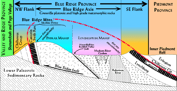 Notice the Blue Ridge thrust fault at the base; the Blue Ridge province has been moved westward from its site of origin, perhaps as far east as Richmond. Below the Blue Ridge fault Cambrian and Ordovician sediments ("Lower Paleozoic Sedimentary Rocks") of the Valley and Ridge extend eastward under the Blue Ridge and piedmont provinces (cross section). Descriptions of Rock Units (in stratigraphic order beginning with the oldest on the bottom). Formations include Shady, Rome, Elbrook, Conococheague, Stonehenge, Beekmantown, New Market, and Lincolnshire. These rocks were thrust over by the Blue Ridge rocks during the Alleghenian orogeny. A larger view of the relationships of these rocks to the Blue Rige and be found in this cross section. These are interpreted as mid- to distal shelf deposits transitioning into slope and rise deposits of the Proto-Atlantic divergent continental margin (blurdgnesw). They would have been deposited above and to the east of the Proto-Atlantic axial rift. The mafic/ultramafic units are probably remnants of oceanic lithosphere (ophilolite suite). The Antietam is a quartz sandstone (metamorphosed to a quartzite) with the trace fossil Scolithus, indicative of a beach deposit (blurdgnesw). These are interpreted to be flows accompanying the opening of the Proto-Atlantic ocean basin. The Lynchburg is only one part of a series of related clastic sedimentary deposits found all up and down the Blue Ridge province. It includes the Mechum River graben in the center of the drawing above (but recent work indicates it may not be a graben at all). In addition to the Lynchburg Group is included the Ocoee, Grandfather Mtn., and Mt. Rogers groups (NW flank, SE flank), sometimes accompanied by Crossnore volcanic pyroclastics and lava flows. Stratigraphic thicknesses range from about 3000 meters to 7000 meters. In virtually all these cases the graben borders are not preserved and their structure must be inferred from stratigraphic and other evidence. The Crossnore is an igneous event dating from about 800 mya to 600 mya. It includes the remains of two rhyolitic volcanic piles (only one in Virginia), and an intrusive alkali granite batholith. The remains of one volcano is found in southcentral Virginia in the Mt.Rogers area. The second volcano is at South Mountain in southeast Pennsylvania. The Robertson River batholith lies geographically between these two volcanic piles in the northern most part of the Blue Ridge province. It is intruded into Grenville metaplutons. All of these igneous rocks are closely associated with rift grabens and aulacogens. UNCONFORMITY - an approximately 600 million year break in the rock record during which time the Grenville mountains were eroded down to a peneplain. Grenville. The oldest rocks in Virginia (1.8-1.1 billion years) running in a NE-SW trend down the backbone of the Blue Ridge physiographic/geoglogic province (province map). They are dominantly deep forming igneous rocks (granite, granodiorites, etc.) having undergone various degrees of metamorphism to produce gneisses. Many are exposed along Skyline Drive in the Blue Ridge mountains, and in a strip of land to the east running from Galax north through Charlottesville and Culpepper. Related rocks are found all up and down the east coast from Newfoundland to North Carolina. In addition, the basement underlies most of eastern North America, including the Valley and Ridge and Allegheny plateau provinces in Virginia. A large fault system (the Haysville-Fries-Rockfish Valley fault; HFRV) cuts down the middle dividing the Grenville rocks into the Pedlar massif to the northwest, and the Lovingston massif to the southeast. The fault probably represents a Grenville suture, but was reactivated in the Taconic. |