 Cross Section
B (Next Cross Section ) (Previous Cross Section) (Home) Early Paleozoic Rifting Earliest Cambrian; about 570 mya 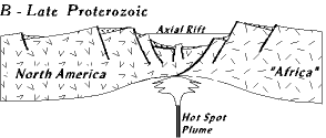 PROSPECTIVE: A rifting is the opening of an ocean basin, and the creation of a divergent plate tectonic boundary. Rifting events create new ocean basins that begin so narrow they barely exist (the Red Sea is a modern example), and open to thousands of miles width, like the Atlantic or Pacific. Rifting events are the first half of a Wilson cycle, and often begin within continental boundaries, and tear large continents into smaller pieces, each a separate continent. The Virginia rifting described here rifted apart the supercontinent Rodinia created in the Grenville orogeny, and created the Proto-Atlantic ocean: We follow this through Stages B, C, and D. THE DEMISE OF THE GRENVILLE MOUNTAINS Mountains never survive long geologically. After the Grenville orogeny eastern North America began a several hundred million year period of tectonic quiet (from about 1.1 billion to .57 billion). "Africa" and North America were fused into a supercontinent (Rodinia), with Virginia located somewhere in the middle. No ocean existed along the east coast of Virginia from 1.1 to about 570 mya. In this span the Grenville mountains have more than enough time to erode down to sea level (a peneplain). [A mountain can erode to sea level in about 20 milliion years.] By the late Proterozoic (600-570 mya) the entire area is flat, featureless, and barren since neither land plants nor animals have evolved yet. We could have walked dry shod across what there was of Virginia (everything west of the Blue Ridge) and right onto "Africa", without breaking much of a sweat. PROTO-ATLANTIC RIFTING But during the latest Proterozoic and earliest Cambrian, North America and "Africa" start to rift apart forming the new Proto-Atlantic (also called Iapetus) ocean. The rifting event extended for thousands of miles up and down eastern North America. In Virginia the axis of rifting runs right down the Blue Ridge province. Structurally, rifting takes place when continental crust, heated from below by a hot spot (a plume of magma rising from the earth's interior), swells upward, thins, and streches out like pulled taffy (notice the thinning in the cross section above). At depth the rocks are hot and plastic, but at the surface they are cold and brittle, so when they stetch with the uplift, cracks form and develop as normal faults. Along the faults some blocks of the earth slide downward and form valleys called graben; the adjacent blocks that move up to form mountains are called horsts (cross section). The relief, or difference in elevation, from the top of the horsts to the bottom of the graben can be many kilometers. So in a sense rifting begins with mountain building also, only where mountains like the Grenville are produced by compression from a collision between continents these horst mountains result from uplift, stetching, and tension caused by heat from below. In the center of the system there is the axial rift (or axial graben), a narrow, steep sided valley maybe only 50-100 kilometers wide but falling a kilometer or more below sea level. Early in its history it may be dry, but in time the sea spills in filling it. On either side of the axial rift, horsts rise abruptly two or more kilometer above sea level. These horst blocks bordering either side of the axial rift are the continental terraces, or hinge zones (Rift section 1-2). 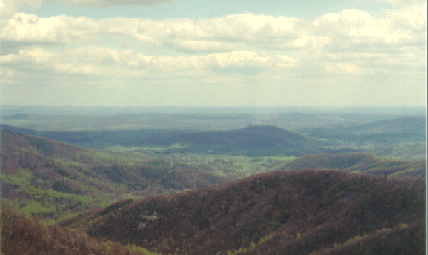 Today the remnants of this axial rift runs through the Charlottesville and Culpepper region. The sedimentary rocks (Lynchburg Group, see cross section) there tell us that during rifting the long, deep rift valley received coarse gravels and sandstones from the surrounding horst mountains on both sides. The western side of the rift graben is North America, but the eastern side, was "Africa". You can almost imagine this while standing at one of the east facing overlooks along Skyline Drive today, such as this picture looking east from the Buck Hollow overlook a few miles south of the Thornton Gap entrance to Skyline Drive. Looking east over the low lands below of the Blue Ridge and Piedmont provinces it is almost like you were standing on one side of the rift valley looking down into the graben. Out there in the distance is the Lynchburg group, sediments that filled the axial rift. And somewhere off in the distance, "Africa." Today the remnants of this axial rift runs through the Charlottesville and Culpepper region. The sedimentary rocks (Lynchburg Group, see cross section) there tell us that during rifting the long, deep rift valley received coarse gravels and sandstones from the surrounding horst mountains on both sides. The western side of the rift graben is North America, but the eastern side, was "Africa". You can almost imagine this while standing at one of the east facing overlooks along Skyline Drive today, such as this picture looking east from the Buck Hollow overlook a few miles south of the Thornton Gap entrance to Skyline Drive. Looking east over the low lands below of the Blue Ridge and Piedmont provinces it is almost like you were standing on one side of the rift valley looking down into the graben. Out there in the distance is the Lynchburg group, sediments that filled the axial rift. And somewhere off in the distance, "Africa."We, of course, always want to imagine what these ancient world's would look like if we could be there. What would it really be like to stand on the continental terrace and look around during the rifting event? Usually we rely on artists and movie makers to create these images for us. It is a great challenge to look at cold, hard rocks, and see the landscapes that created them. 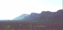 We can get some ideas by looking at modern examples of rifts that match the Proto-Atlantic rift at the moment we are describing here. The right hand picture, for example, is the continental terrace and axial rift of the East African rift system just west of Nairobi, Kenya, Africa. Notice how high the horst is, and how abruptly it drops into the rift. Virginia during the Proto-Atlantic rifting just before the sea invaded the rift probably resembled this.
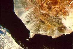 And to the right is a satelite view of the Gulf of Aden. The black area is the newly opening ocean basin in the axial rift. The brownish rugged regions to the upper right are the horsts that compose the contiental terrace. And inbetween, the ligtht colored, almost white, area are the alluvial fans and braided rivers carrying sediment down into the rift.
 The satelite image below right of the Red Sea in the Middle East shows a modern axial rift after the sea has invaded, and just as oceanic lithosphere begins to form and create a new ocean basin (click image for enlargement and description). 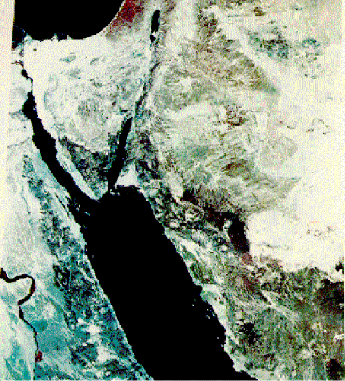 But we must be cautions, for some things were different in the Proto-Atlantic rifting. For one, no plants or animals had evolved yet so the lushness of the African scene would not be Virginia. Imagine instead baren rock. For two, modern east Africa is in the tropics, but in the Virginia rifting there is much evidence that glaciers existed. So now imagine these horsts covered with ice streaming through valleys down to the rift floor, and then into the invading ocean waters. It is fun to take these imaginary trips into the past, but it is also important to not confuse what existed in the past with what exists as we travel around today. True, the horst and axial rift did exist down the axis of the Blue Ridge province in the Late Proterozoic, as the rock record tells us. But the geology in the Blue Ridge today is not a horst and graben system as we tried to imagine from Buck Hollow overlook (although a horst/graben system is preserved there), but an overturned anticline. The rock record is like a palimpsest, an old document where a previous text has been erased, but not completely, so that another text could be written over it. We clearly see the latest text, but beneath it is another text, largely hidden, that may be about something completely different. So now we have an axial rift, but in time the horsts will erode, and the axial rift fill with sediments. But before that process is finished the rift valley continues to spread apart, changing into a newly opening ocean basin (Rift Section 3), explored more in Stage C.
|