 Cross Section
K (Next Cross Section) (Previous Cross Section) (Home) The Late Paleozoic Alleghanian Orogeny Mississippian, Pennsylvanian, and Permian; 320 my to 250 my 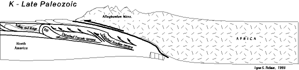 A SYNOPSIS OF THE ALLEGHENIAN OROGENY The Alleghanian orogeny is the last major orogenic event to affect the Mid-Atlantic region. (The present Appalachian mountains are the result of gentle uplift not involving plate boundary processes, and are thus not true mountains in a geological sense). The orogeny occurred when northwest Africa, a part of the supercontinent Gondwana collided with the eastern seaboard of North America closing the Proto-Atlantic (and Rheic) oceans. The collision resulted in several associated orogenies; the Mauritanide (the complementary orogeny on Africa opposite the Alleghanian), the Ouachita (South America striking the Gulf Coast region), and the Hercynian (Gondwana colliding with southern Europe). All of these orogenies sutured together the supercontinent Pangaea. By the Alleghanian orogeny, Virginia had already been through two collision orogenies (Taconic and Acadian), but the Alleghanian differs significantly. With the Taconic and Acadian, Virginia not only had mountain ranges in the east, but also large foreland basins in the west in which was deposited excellent sedimentary records. Furthermore, although the western part of the state was down warped into foreland basins, the pre-existing underlying rocks were relatively unscathed structurally (almost no recognizable internal folding or faulting). 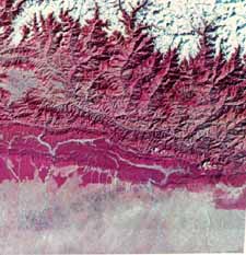 But with the Alleghanian orogeny virtually the entire state becomes mountain range, probably Himalayan size, as in the image to the right (click for more details); imagine Richmond sitting at the bottom of a Mt. Everest sized mountain. And in the process virtually all of Virginia's rocks are structurally deformed; folded, thrust faulted, and moved significant distances from their original locations. Virtually all of the landforms, physiographic provinces, structures in roadcuts, etc. we see in the state today reflect this event. The only exceptions are the Triassic basins and the coastal plain. which did not exist until after the Alleghanian orogeny.
In the Alleghanian orogeny, Africa (Gondwana) became a hinterland meaning it was thrust up and over the North American edge. We do not know how far Africa thrust over Virginia, but conceivably all the way out to the Allegheny Front. That means that during the orogeny, the North American rocks were shoved down rather deep in the earth by the weight of Africa, and most of Virginia had Africa sitting on top of it. None of Africa remains here, by the way. All of it was removed by erosion and transported westward as sediments into the foreland basins. The Alleghanian foreland basin then developed farther west through Kentucky, West Virginia, western Pennsylvania, Ohio, and beyond. Virginia has only a small part of this foreland record in the far southwest part of the state, but it is typical and representative - deltas, coastal margins, and coal swamps teaming with lots of bizaare life. ALLEGHENIAN OROGENY AND THE END OF A WILSON CYCLE The Alleghanian is not only the last orogeny to affect Virginia, it is also the completion of a nearly 300 million year Wilson cycle. The cycle began with one late Precambrian supercontinent Rodinia, and one superocean. All the individual continents were packed together, with North America in the center, and Virginia somewhere in the middle, protected and geologically stable. The cycle continued in the latest Precambrian and earliest Cambrian when the supercontinent rifted apart creating the Proto-Atlantic ocean (Stages B and C). The new Virginia coast was left exposed and vulnerable to future plate tectonic events. The rifting event is reflected in the outpouring of basalt lava flows (i.e. the Catoctin formation) now exposed in the present Blue Ridge. After the continents scattered across the globe the rifting reversed, convergent boundaries and subduction zones became active, and the Protoatlantic/Rheic oceans closed. The oceans closed in stages causing the Taconic, Acadian, and, now, the Alleghanian orogeny. The Alleghanian orogeny assembles all the scattered continents of the late Precambrian supercontinent back into another supercontinent, Pangaea, closing the Protoatlantic/Rheic oceans shut, which encloses Virginia in the middle again, and completes the cycle. With the creation of Pangaea the earth now contains one supercontinent again, and one large ocean, Panthalassa (although the Tethys sea lies between northern Africa and southern Europe. One could walk dryshod from Virginia to Africa, although for a time it will require climbing a Himalayan-sized mountain range to do it.  The structure is important, in part, because it creates the basis of our modern landscape, but also because it is an excellent record of this kind of mountain building; a classic case of great scientific significance. The sedimentary record is important, in part, because some of the largest coal reserves in the world are contained within them. Those reserves fueled the industrial revolution, and helped build the United States into the superpower it is. It is easy to underestimate their importance, geologically or for human history (even including all the environmental disasters of mining). Because both these records are important the scientific research on them is overwhelming, and we can only touch on its more significant aspects. Our first emphasis will be on the structure, since that is what dominates the Mid-Atlantic record. Below, then, we examine the sedimentary record.
Virginia on the Eve of the Orogeny (See detailed analysis for a more thorough explanation.) Modern landscapes and geologic relationships so dominate our views that it can be hard to imagine the past. This is especially true for the Alleghanian orogeny, because relationships among the rocks before and after the orogeny are profoundly different. The Alleghanian orogeny not only faults and folds Virginia's rocks, it also severely displaces most of them westward. To reconstruct the pre-Alleghanian world we have to restore all this displacement. The result is something like the cross section below. This is the Mississippian cross section, but approximate modern geographic positions are indicated on it. 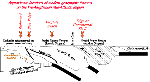 Superimposed on the Grenville rocks are the Proto-Atlantic rift graben, and all the other deposits associated with the rifting event. Since rift graben normally form and exist on the edge of continents, the pre-Alleghanian location of this rift zone would represent the edge of the ancient continent. Upon unfaulting and unfolding the rocks, we find that boundary close to the eastern edge of the present day piedmont; about where Richmond is. Sedimentary basins now found in the Valley and Ridge (DCM, foreland basins, etc) covered most of what is present day Virginia, including areas now occupied by the Blue Ridge and Piedmont. To appreciate what all this means for ancient and modern geography, observe that the reconstructed location of the Taconic and Acadian terranes in the drawing above is east of Richmond, while their present locations in the piedmont are west of Richmond. Similarly the Proto-Atlantic rift is now exposed in the Blue Ridge province, not buried deep in the earth under Richmond as it was before the Alleghanian orogeny. Environmental Reconstruction: What would it have been like to be here in the Mid-Atlantic on the eve of the Alleghanian orogeny? By now the Taconic and Acadian terranes have both been peneplained; eroded down virtually flat. Beginning at Richmond, if you walked east across them you would have seen first the exposed batholiths of the Taconic volcanic arcs/microcontinents, and east of that the suture zone where the Taconic and Acadian terranes join together, and east of that the exposed basement batholiths of the Avalon terrane. Now walk west from Richmond, to the inland coast of the Absaroka sea. Along the edge are the carbonate tidal flats of the Greenbrier Formation, and west of that the oolitic shoals and crinoid meadows extending across the continent. We really do not know how far east this coastline came. The presence of tidal flat deposits along the present Allegheny Front tells us, at times, it was that far west. But with a higher sea level and a low sourceland it could have come farther east; in the cross section it is brought rather far east, but we really don't know. But before we leave, let us now stand on the very eastern coast of the eroded Avalon terrane, looking out into the Rheic ocean, for our future lies there. If you look carefully, along the edge of the horizon, you might see the tops of the volcanos building along the edge of northern Africa (Gondwana) by a subduction zone. Soon Gondwana will slam into this older Mid-Atlantic coast line, slide up over the eastermmost edge, and move tens of miles inland crumpling and displacing all the North American rocks underneath and in front of it. And this Pre-Alleghanian geography lesson we have just gone through will be for naught. Large Scale Structural Relationships and Displacements Now, finally in our story, Gondwana collides with this older Mid-Atlantic. Actually, it collides first with the Avalon terrane. And as it hits, the east-dipping subduction zone acts as a ramp, allowing Gondwana to slide up over the edge of Proto-North America (cross section at top). Just the weight of Gondwana, and the horizontal stresses of its movement would be enough to deform the underlying rocks, but additional zones of weakness exist. Old sutures associated with extinct subduction zones, and the faulted Proto-North American continental edge detach and begin to move as well. The most characteristic feature of Alleghanian structural deformation is that large sheets of rock slide westward along great, nearly horizontal thrust faults. The scale and scope of this is captured diagrammatically in the cross- section at the top of the page (section K). Notice that as Gondwana slides up over the edge of Proto-North America that both the Taconic and Acadian terranes detach and move inland. But the detachments penetrated deeper still, all the way down to the once thinned and stretched Grenville basement rocks at the old continental edge. Great slabs of this break free, and moved inland, taking the Proto-Atlantic rift graben with them; great blocks of the earth, breaking free and moving along slippery zones of weakness. To get some idea what happened, think back to the description of Virginia on the eve of the orogeny (above). With Richmond as a reference point, we noted that the Taconic and Acadian terranes were originally east of Richmond, while today they are obviously west of Richmond. Similarly, Richmond today lies above the original location of the Proto-Atlantic continental edge. But the Proto-Atlantic axial rift, originally buried at the bottom of the rock pile is now preserved farther west in the Blue Ridge. That is to say, most of the things originally east or below our Richmond reference point moved west and up during the Alleghanian orogeny to become the modern day Piedmont and Blue Ridge provinces (details). But you have to remember, along the easternmost margin all this is taking place underneath the overriding African continent, now long since completely removed by erosion. At these depths the rocks are hot, and the pressure is very high, and the normally brittle rocks become soft and plastic, moving and folding easily. But what of the stack of DCM and foreland basin sedimentary rocks that originally occupied those regions west of the original locations of the Taconic and Acadian terranes? Well, they start to move too, but because they are sedimentary rocks, layered and flat lying, with slippery zones scattered among them, they behave differently. Great thick slabs of rock, greased by the slippery zones, begin to break and slide, stacking up in multiple layers tens of thousands of feet thick. Underneath the moving Blue Ridge and Piedmont rocks the weight causes the sedimentary layers to slide over each other largely horizontally. But out in front, west of the Blue Ridge front, the sedimentary layers are bull dozed, and crimp and fold. We really do not know how far Africa slid over Proto-North America, but we can see how far the stresses moved. Rocks throughout the Valley and Ridge are thrust faulted and folded, but at the Allegheny Front it comes to a more or less abrupt halt. Just to the east of the front the rocks are severely deformed; in places they almost look like they have been rammed at high speed into an impenetrable wall. But then just a few miles west, out in the high Allegheny plateau, the rocks are nearly flat lying or mildly folded. We can see this well in the Cumberland satellite photo and description, and in this structural cross section (in preparation). We do not know why deformation stopped at the Allegheny Front, but this front begins in Pennsylvania and runs continuously all the way down to Tennessee. Perhaps it represents the farthest inland that the African terrane overrode North America. So, now we have rearranged all the rocks in the Mid-Atlantic, taking them from their original locations and moving them to new locations. It is only now that the Physiographic/Geologic province descriptions begin to describe the Virginia we know today. ALLEGHANIAN STRUCTURAL DEFORMATION Styles of Structural Deformation Structural geology is fractal. That is, deformation exists at all scales from the miniature to the mountain, and every size in between. Some things you can only see with a microscope, and other things you cannot see unless you "can see the world in a grain of sand." To a structural geologist all these features are integrated parts of a whole. The large scale structures can be inferred by the smallest structures, and from the largest structures we can predict the nature of microscopic structures. We want to illustrate this structural diversity, looking at both smaller structures (megascale), the kind you can see easily in road cuts, as well as structures so large (macroscale) they dwarf us, and can be recognized only if you know what you are looking for. None of these will truly capture the regional picture of Alleghanian deformation, which exists at an even larger, continental, scale. To do that we need to go to the "further detail" pages. Structural geology is a discipline all its own, and requires a little theory before we systematically explore some of the wonderful things about Appalachian geology. Some Expressions of Alleghanian Structural Deformation Most people unfamiliar with geology just do not think of the origin of the land around them; I know this was true for me before I studied geology. Oh, the hills and valleys are there, but we don't see the pattern in it all. It is just landscape, like the background in a painting that is only a setting for the images in the foreground. But, in fact, all that landscape really does have meaning. In the western U.S. there is so little vegetation the rocks stand out boldly. You can see the rock structure's easier, even if you do not understand it. Perhaps that is why people from the west are more aware of the geology; they can't escape it. In the eastern U.S. most of our rocks are lost in the lush vegetation. You can drive over and past the most fascinating geology, and none of it is exposed to see. Even a geologist studying the rocks has to scrape around through the vegetation looking for a few precious outcrops, which by that time are often so weathered they look nothing like their former selves. This simply makes eastern geology far more challenging. In the past few decades this situation has significantly changed. Construction of the interstate highway system has torn great gashes in the sides of mountains, and even the widening of secondary roads has produced a wealth of outcrops. Rarely have Appalachian geologists had so much to study. 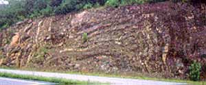 These days it is hard to take a trip very far without seeing an outcrop of rock, such as the folds in the picture to the right along U.S. Rt. 50 west of Winchester. The rocks are Devonian, deposited in a submarine fan during the Acadian orogeny in the Catskill foreland basin. But, of course, rocks are not deposited in this folded, twisted pattern. Sedimentary rocks are, for all intents and purposes, deposited horizontally, so when we see them folded like this we know it is the result of a later event. And in the Appalachians that deformation is generally (with some exceptions) Alleghanian in origin.
So, as you drive around the state keep an eye open for roadcuts, and look at the rocks exposed there. Better yet observe how the rocks change from outcrop to outcrop; they are related in some fashion. Often it is possible in only a few miles to pass from rocks deposited under one set of geologic circumstances to those deposited in an entirely different set of circumstances. All thanks to the Alleghanian orogeny. There are exceptions in your travel, though. Throughout the Coastal Plain and the Piedmont it is very hard to find any outcrops. And even when you do they are often so badly weathered it can be hard to even identify the rock. Yet, certainly in the Piedmont from years of work we know that there is a wealth of fascinating geology; old volcanic arcs, old suture zones, and younger Alleghanian faults, which just highlights the problems of the geologist. But let's take a closer look at how the Alleghanian orogeny created some of our scenery with examples of two transitions: one from the Blue Ridge to the Valley and Ridge provinces, and a second from the Valley and Ridge to the Appalachian plateaus. 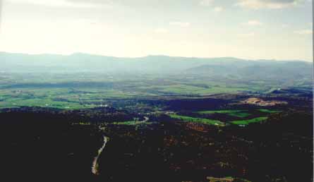 Blue Ridge Thrust Fault: We can easily drive over the most interesting geology, and not know it. For example, the picture to the right was taken from New Market Gap on Massanutten Mountain, a few miles west of Luray, Va., looking eastward toward the Blue Ridge. Page Valley is in the foreground. A picturesque scene that involves much geology.
 The Blue Ridge contains the Grenville basement rocks, and the Catoctin lava flows that accompanied the opening of the Proto-Atlantic (cross section). Furthermore, from the explanation above we also know the Blue Ridge rocks have been moved westward along the Blue Ridge Thrust Fault (cross section). So, as we approach the base of the Blue Ridge mountains along Rt 211 we cross a great fault. You will not see it as you drive, and even a geologist new to the area would probably miss it. The rocks are so different across the fault the geologist may, however, suspect some geologic event change. As soon as we cross the fault, traveling west, we leave the Blue Ridge Province and the Grenville suite of metamorphic and crystalline rocks. Now within the Valley and Ridge, the first rocks we encounter, although it is hard to find exposures, are carbonate tidal deposits of the Proto-Atlantic divergent continental margin. All these carbonate rocks have been folded and faulted during the Alleghanian orogeny, and thereby Massanutten Mountain represents the axis of a huge syncline (cross section). Allegheny Front Transition: The picture below was taken at Germany Valley, Pendleton Co. W.Va. It is a panorama so we have to get oriented. Looking just to the right of center is looking northeast, along the trend of the mountains. That is the direction all the mountain ridges in the Valley and Ridge trend, as can be seen in the Cumberland satellite image, or at the Smoke Hole link. The highest, long ridge on the left side of the picture is the Allegheny Front. It is the boundary between the Valley and Ridge and the High Allegheny Mountain Plateau. The valley in the foreground is Germany Valley. 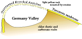 Structurally it lies within an overturned breeched anticline. That is, before the valley eroded out it was roofed by a great dome of rock, arching high above the picture. The cross section to the right shows this arch diagramatically; the far right ridge in the photo is the eroded right side of the drawing; the left side of the drawing is the closest low ridge in the photograph. The jagged edge of the ridge on the right is comprised of the Tuscarora sandstone; a tough, resistant unit. The Tuscarora originally arched out over the center of the photo connecting with the nearest long sharp ridge on the left side (just a few miles NE it forms Seneca Rocks). Below ground is a thrust fault along which all these rocks moved during the Alleghanian orogeny (it is similar to the Blue Ridge thrust fault and overturned anticline.
 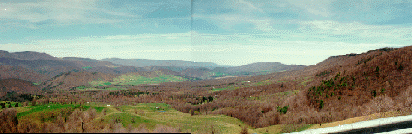 What we have to remember through all this is that rarely will we be able to actually see the big picture; the totality of the Alleghanian mountains within the panoramic view or outcrop. Instead we have to reconstruct in our mind's eye what this mountain building was about. Part of the difficulty will be that most of the mountains have been eroded since the orogeny. Africa (Gondwana) has been removed completely, and only the roots of the deformed North American rocks remain. So, we are not only trying to piece together a picture of relationships among rocks that exist today, we are also trying to reconstruct rocks that no longer exist. Two examples of how we do this are linked below.
As this sediment traveled it met up with sediment traveling north from the Ouachita mountains along the Gulf Coast (which also did not exist, instead being replaced by South America) and together they spread through Oklahoma and Texas (Pangaea map, blue arrows). A large chunk of Africa, and South America, eroded into astronomically uncountable grains of sand and spread across two-thirds of the North American continent. Imagine it. By the time it was done, so much sediment had been deposited that the Absaroka sea was pushed right off the continent through a small corridor in southwest Texas. North America would never again experience the great inundations of the sea that so dominated the previous 300 million years. Mostly dry land from here on out; a continent we can live on. Even today as you drive across much of the eastern United States what you drive across are these sedimentary layers from the Alleghanian orogeny. Unfortunately the Mid-Atlantic region has virtually no record of all this sediment; instead we were the sourceland, destined to be eroded down flat to a peneplain, the fate of all mountain ranges. Only Virginia has a record, and it is confined to a small outcrop belt in the southwestern corner of the state (including Scott, Russell, Tazewell, Lee, Wise, Dickenson, and Buchanan counties; that is the Appalachian Plateau portion of the state). But it is the beginning of the huge clastic wedge of sediments that spreads westward. Southwestern Virginia, being closest to the mountains, of course receives some of the thickest accumulations; nearly three miles thick. From there it thins westward. When mountain building was just beginning, marine shelf and shoreline (beach, lagoon, swamp) environments dominate the record. These shoreline environments were similar to the east coast of Virginia and North Carolina today with their barrier islands, lagoons, and tidal marshes, although the tectonic conditions are very different. (Plus also notice that the geography is reversed. The mountains are in the east, and the shoreline in the west; but we have seen this before.) As sediment accumulated and spread westward, deltaic coal swamps and terrestrial environments take over. It is not clear why, but deltaic depositional environments do not exist before the late Paleozoic, and they certainly never existed on the scale they do here. Think of being here in the Late Paleozoic. This is a bit of an exaggeration, but imagine most of eastern North America (west of the Alleghanian mountains) looking something like the Dismal Swamp of North Carolina and southeastern Virginia, or the Everglades of Florida, or the bayou country of southern Louisiana. North America lies in a subtropical region and the air is hot and heavy with humidity all year round. It probably rains nearly every day. And the place is just choked with vegetation; seed ferns, scale trees, and sphenopsids growing dense and thick, and the trees towering over head. And underfoot is a soggy mess, a thick undergrowth littered with the tangled remains of decaying plants, accumulating layer after layer of peat, eventually to become coal. And through all this, arthropods, everywhere, crawling in the dank undergrowth, and buzzing through the air; centipedes, and millipedes, and insects, (some as much as a foot long), and dragon flies with wing spans of 29 inches. And crawling among all this vegetation, and swimming in the lakes, swamps and rivers numerous strange labrynthodont amphibians, now extinct, but some up to six feet long and behaving something like crocodiles (which have not yet evolved). And lepospondyl amphibians, some snake-like, some salamander-like, and some with bizarre wing shaped heads. And the earliest reptiles just coming out of the water. What a vision! What a world this was, this late Paleozoic world. So different from our own, so different from strip-mine-scarred Appalachia, and acid mine drainage, and impoverished mountain homes, but lying there, just under our feet, if we can only learn to read the rocks. But reading the rocks takes a little more effort, pursued in the "more detailed" portions.
|