|
Rationalle For the Reconstruction 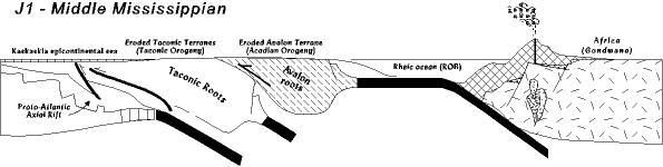 Modern landscapes and geologic relationships so dominate our views that it can be hard to imagine the past. Even professional geologists have to work at making the transition from the rocks they see in front of them in a road cut, to what the world was like at the time those rocks were forming. This is especially true for the Alleghanian orogeny, because relationships among the rocks before and after the orogeny are profoundly different. So, let us try to picture Virginia on the eve of the Alleghanian orogeny, beginning with the most obvious divisions, the geologic/physiographic provinces. When Gondwana collided with North America neither the Coastal Plain nor the Triassic rift basins existed. They are the future, so we have to imagine the Mid-Atlantic world without them. Of what remains, we largely ignore the Allegheny Plateau since it is far enough inland that about the only thing it does is accumulate layer after layer of sediment from events occurring to the east. What remains is the Valley and Ridge, Blue Ridge, and Piedmont (physiographic map). We already know two things about these rocks. First, many of them are terranes, volcanic arcs and microcontinents brought in in stages during the Taconic and Acadian orogenies. And, second, these rocks undergo a lot of structural displacement during the Alleghanian orogeny. It is these relationships we have to untangle. But first a review of the rocks we are dealing with, and their modern spatial relationships (from west to east): Restoration Work: Getting Rocks Back to their Original Locations The Valley and Ridge and related sedimentary rocks are found in two locations. First are rocks found in the modern Valley and Ridge (cross section). Although these are folded and thrust faulted, they are essentially in their Paleozoic position relative to the other provinces. That is, east of the Allegheny plateau and west of the Blue Ridge/Piedmont. But, because they have been foreshortened by the Alleghanian structural deformation the pre-Alleghanian Valley and Ridge province must have been wider than it is today, perhaps several times wider. We can get some idea of the degree of forshortening by looking at the second group of Valley and Ridge-type rocks. The second group of pre-Alleghanian sedimentary rocks extend east under the Blue Ridge and Piedmont all the way out to about Richmond (cross section). We presume these are Cambrian and Ordovician in age, making them part of the divergent continental margin wedge, but since they are buried we really don't know for sure. These subsurface sedimentary rocks are mostly horizontal and unfolded, and at least the bottom layer is sitting conformably on basement; that is, they are sitting as they were deposited on the underlying igneous and metamorphic rocks of the North American continent. These rocks have probably not moved since they were deposited, and we can use them as a reference for figuring out where all the other rocks go. The result of these relationships, however, tell us the Valley and Ridge-type rocks were originally in a belt about two or three times as wide as the present Valley and Ridge (cross section), extending about out to the boundary of the current Piedmont and Coastal Plain provinces. That is, out to about Richmond We have reasoned our way to the idea that most of Pre-Alleghanian Virginia, at least out to the eastern edge of the piedmont, existed as Valley and Ridge-type rocks. That is, sedimentary basins. There is also geophysical evidence that this is true. Both seismic studies and gravitational studies indicate that deep in the subsurface under the eastern piedmont are rocks and structures created during the rifting that opened the Proto-Atlantic ocean. This, despite the fact that the axial graben is today located in the Blue Ridge. The Blue Ridge rocks are the Grenville basement and the Proto-Atlantic rift graben. Now, if you think about it, these rocks are really out of place. Even though they are older than the Valley and Ridge rocks, and should be underneath them, they are actually sitting on top of Cambro-Ordovician divergent continental margin sediments, deposited after the rift graben had formed and filled (cross section). What is more, normally rift rocks lie at the edge of a continent, but if the DCM sediments actually extend to the eastern edge of the Piedmont province, then the Blue Ridge rocks are displaced west. So, these rocks are not only on top of rocks they are older than, they are farther west than they should be. To reconstruct the pre-Alleghanian Mid-Atlantic we have to put these rocks back geographically where they belong, probably just about the piedmont/coastal plain boundary, and stratigraphically where they belong (deep in the earth). The Piedmont rocks also have an interesting problem. The Piedmont has dozens of imbricated thrust faults, which means that many rocks now found side by side were separated in the past. How much separated we don't know, but the overall effect is that the Piedmont province is now narrower than it once was. Perhaps it was twice as wide as it is now. Also, the Piedmont rocks, like the Blue Ridge rocks, have been thrust over the underlying horizontal DCM rocks, implying they originally must have existed much farther east than the current location, and farther east than the Proto-Atlantic rift graben now in the Blue Ridge (cross section). To reconstruct the pre-Alleghanian world we have to restore all this displacement and dislocation in the Valley and Ridge, Blue Ridge, and Piedmont. And the result is something like the Mississippian cross section below. At the bottom of the pile are the Grenville basement rocks, stretched and thinned during the Proto-Atlantic rifting. These are not just the rocks now exposed in the Blue Ridge, but all the related basement rocks underlying the east coast. Faulted into the Grenville rocks are the Proto-Atlantic rift graben, and all the other rocks associated with the rifting event. Fortunately, most of these rocks are now exposed in the Blue Ridge province where we can get to them. Since these rocks are the oldest they are, appropriately, on the bottom of the cross section. Then, sitting on top of the Grenville/Rift rocks is the DCM sedimentary wedge. However, just before the Alleghanian orogeny, these rocks are buried under sedimentary deposits of the Taconian foreland basins, and Acadian foreland basin, as well as interorogenic sediments. A thick accumulation of sediments; several tens of thousands of feet. As we catch the scene just before the Alleghanian orogeny the Greenbriar carbonates are being deposited in the tectonically stable Absaroka sea. Virtually none of these rocks have been displaced from their site of deposition at this Pre-Alleghanian time. At this point, the cross section above restores all the pieces spatially, but does not yet restore them geographically. We do that next. Pre-Alleghanian Geographic Restoration In the pre-Alleghanian virtually all of Virginia is sedimentary basin; that is from the far west all the way out to the Paleozoic eastern edge of the continent at the Piedmont/Coastal Plain boundary. This sedimentary basin contains, from bottom to top, rift graben, buried by rocks of the DCM, buried by foreland basin rocks. If we go any farther east than about Richmond we move off the edge of the ancient continent and out into the Proto-Atlantic ocean basin. But out there are the eroded roots of the Taconic and Acadian terranes. Today these rocks are in the piedmont, but in the pre-Alleghanian they must have existed much farther east, certainly east of the original Proto-Atlantic edge of North America. In today's geography this would put the terranes out in the coastal plain region, probably all the way out to the edge of the present continental shelf, and beyond. East of that then, in the Pennsylvanian, is the Rheic ocean, containing Gondwana, closing fast. 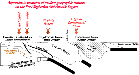 In the cross section above we have indicated possible modern geographic reference points to give an idea of the Pre-Alleghanian locations of terranes. Observe that all these rocks today are found west of Richmond, sometimes far west. But in the Pre-Alleghanian they were east, or in the case of the rift graben, underneath Richmond. So, let us go back and visit the Mid-Atlantic before the collision. Across the area of the present coastal plain are the Taconic and Acadian terranes, peneplained, virtually flat, eroded down almost to sea level. If you could have walked across them you would have seen the exposed batholiths of the Taconic volcanic arcs. These rocks would have been rich in complexity since they contain more than one volcanic arc, and the suture zones between them, and likely microcontinents as well (terrane map). To the east of the Taconic terrane then is the suture zone where the Taconic and Acadian terranes join together, and east of that the exposed basement rocks of the Avalon terrane. And finally to the east of all this, off the eroded edge of the Avalon terrane, is the Rheic ocean. To the west is the inland coast of the Absaroka sea. Along the edge are the carbonate tidal flats of the Greenbriar formation, and west of that the oolitic shoals and crinoid meadows. The presence of tidal flat deposits along the present Allegheny front tells us at times it was that far west. But with a higher sea level and a low sourceland it could have come farther east; in the cross section it is brought rather far east, but we really don't know. Virginia After the Alleghanian Orogeny The effects of the collision of Gondwana with the Mid-Atlantic region was for Gondwana to slide up as a hinterland over the foreland edge of North America. 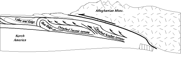 As Gondwana slid it caused many of the underlying terranes and blocks of crust to detatch and move westward. This movement displaced both the Taconic terranes (Arvonia arc, Carlonina slate belt, etc. (terrane map)) and the Acadian terrane (Avalon). It also reached down to the roots of the continent and detatched the stretched and thinned edge of the continent containing the Proto-Atlantic rift systems and shoved them westward to their present location, where they stopped as an overturned, ramped anticline. 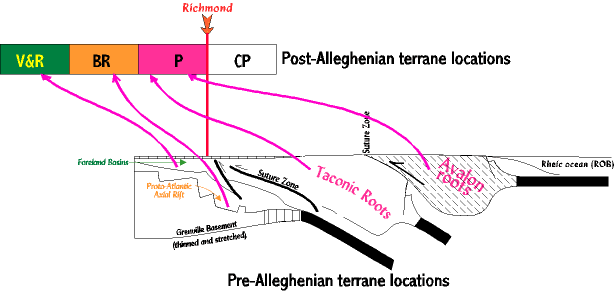 Some idea of the extent of this displacement can be seen in the drawing above comparing pre-Alleghanian and post-Alleghanian locations. The location of modern Richmond is a reference point. Prior to the orogeny the Taconic and Acadian terranes lay east of Richmond, and the Proto-Atlantic rift grabens somewhere below in the subsurface. Directly to the west in what is now the piedmont was the outer edge of the Proto-Atlantic divergent continental margin wedge of sediments, and superposed on that the foreland basins of the Taconic and Acadian orogenies. After the orogeny the Taconic/Acadian terranes had been moved west of Richmond to form the modern Piedmont. And west of that is the Proto-Atlantic rifts, brought up from below by the collision and shoved westward in front of the moving terranes. This, of course, now constitutes the Blue Ridge province with its Grenville basement. These relationships may seem a stretch, but when we look at the structure of the piedmont and Blue Ridge we see they are not that different (cross section). What really separates the Blue Ridge and piedmont is the Blue Ridge exposes Grenville basement while the piedmont contains the suspect terranes. Otherwise the whole complex is cut extensively by decollemnt imbricated thrust faults (link) As for the DCM and foreland basin sediments. Right now, under the piedmont, are horizontal layers of these rocks, and they probably acted as slippery glide planes along which the Blue Ridge and piedmont rocks could slide. Further west, however, in front of the moving Blue Ridge front the Blue Ridge rocks bull dozed the sediments, faulting and folding them in complex patterns (cross section). |