 Cross Section
L (Next Cross Section) (Previous Cross Section) (Home) Rifting of Pangaea: Initiation of the Atlantic Ocean (Triassic and Lower Jurassic; 230 my to 175 my 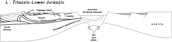 THE UNCONFORMITY There are few times in Virginia and the Mid-Atlantic's history when there is just no rock record at all, nothing to tell us what was happening. One of these record gaps (unconformities) is after the Grenville event at 1.1 billion (Stage B) until the beginning of the Crossnore igneous activity at about 800 million (Stage C). The second gap is after the Alleghanian orogeny. From the last sediments deposited in southwest Virginia during the Pennsylvanian (Harlan formation) through the Permian, and until the late Triassic there is no geologic record in Virginia or the rest of the Mid-Atlantic to tell us what what going on. The best we can do is speculate based on conditions before and after, and reasoning from geologic principles and similar situations today. We do know that Virginia lay deep within the supercontinent Pangaea, and that Virginia was firmly connected to northwest Africa. We are reasonably sure that during the Permian the last parts of the Alleghanian mountains were eroding because a few layers of sediment eroded from them remain in West Virginia and southwest Pennsylvania (called the Dunkard). By the lower Triassic, though, Virginia had little or no geological activity, and little topographic relief. Likely though it was a high, broad, flat plateau since the great thickness of coal containing sediments that had accumulated on the western side of the Alleghanian mountains would have prevented erosion much below that level. On the other hand, rivers were either beginning or were actively incising deep canyons into the plateau. We base this on the deep erosion (last unconformity in the stratigraphic column) into the Pennsylvanian sediments found in southwest Virginia, although we have no way of knowing exactly when this erosion took place, except that it took place after the Harlan formation was deposited. The erosion cut deep, however, all the way down to the Bluestone formation, something over 2000 meters of section . We also know from other evidence that most of North America to the west was land area, built up by rivers carrying the sediment eroded from the Allgehanian mountains into the Absaroka sea. Some of these long, east to west flowing river systems likely had their headwaters in Virginia, and flowed for thousands of miles before finally entering the ocean through southwest Texas and Mexico. Physiographically, as erosion began, the landforms may have developed and looked similar to those today since most of the structural geology that underlies and helps create today's topography was in place by this time. The Valley and Ridge, Blue Ridge, and Piedmont were all in their modern locations, with their modern structures, although not eroded as deeply as they are now. Still, for example, the Valley and Ridge structure of imbricated ramp and flat thrust faults would have produced a trellis drainage pattern similar to today with long resistent ridges alternating with long softer valleys (cf. Cumberland image). And the Alleheny Plateau would also have possessed dendritic drainage, much as it does today. It is harder to guess what the Blue Ridge and Piedmont were like, but also perhaps not dramatically different from what we see today. One major difference, however, is that where the coastal plain is today lay Africa. Fomation of the coastal plain is in the future. And, of course, the Triassic rift basins also have yet to form. So, as best we can sketch on the available evidence, on the eve of the Atlantic rifting the Mid-Atlantic probably looked very similar topographically to the world we have today. There would be differences, of course; the vegetation in the forests would look very strange to our eyes; no hard wood trees, or flowering plants. Instead cycads, and ginkos, and conifer trees. And the animals scurrying around under the canopy would have been early ruling reptiles (on their way to dinosaurs) and synapsids (mammal-like reptiles), but not a mammal in sight, not quite yet; but they are evolving fast. And no birds. A world at once familiar, and strange. SYNOPSIS OF THE ATLANTIC RIFTING EVENT For as sparce as the geologic record is during the unconformity, by the late Triassic there is a rich record on both sides of the Atlantic, from northern Greenland to the tips of South America and Africa recording the initiation of renewed geologic activity. The supercontinent Pangaea, built during the Alleghenian and Ouachita orogenies, is beginning to rift apart. The rifting event, once begun, proceeds rapidly, for by the early Jurassic ocean crust is beginning to form, and the Atlantic ocean open. Pangaea fragmented in stages. It first split along an east-west line running through the present Mediterranean sea region (then called the Tethys sea) forming a northern continent, Laurasia (North America, Europe, and Asia), and a southern continent, Gondwana (South America, Africa, Antarctica, India, and Australia). Then Laurasia and Gondwana each split, in stages, east and west to open the Atlantic ocean. A large number of triple junctions are identified with the opening of these ocean basins, and well over 100 graben. From this evidence the stages in the opening can be dated. First, northwest Africa rifted from eastern North America (210-170 mya). Then South America rifted from southwest Africa (145-125 mya). Then, Greenland rifted from North America (80 mya). Then the Scandinavian countries split from Greenland (80-60 mya). Several other smaller episodes of rifting are also recognize, all resulting in the Atlantic ocean basins present today. The Rift Record Although each rifting event has its own unique history, all rifting events follow similar processes, and produce similar results. We have already developed a rifting model, and examined the Proto-Atlantic rifting event in some detail (Stages B, C, and D) so the discussion below proceeds with that background assumed, although we will refer to it in places. 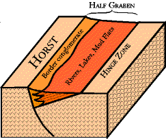 All rifting events begin with formation of an axial rift system, the gash in the earth through which a new ocean basin develops. Associated with the axial rift, however, are a whole host of lateral half-graben, running parallel to the axial rift, but up to 500 km inland on both sides from the axial rift.
 For the Proto-Atlantic rifting we have an excellent record of the axial rift running down the axis of the Blue Ridge (Blue Ridge province), (Stage B) but not the lateral graben, which exist to the west as the Rome Trough buried deep in the subsurface under Kentucky, Ohio and western West Virginia. For the Atlantic rifting the situation is reversed, the lateral graben are for the most part well exposed in the Mid-Atlantic, and the axial rift is buried far to the east (map below). There are a couple of reasons for this difference. First, the Proto-Atlantic axial rift was thrust upward and westward during the Alleghanian orogeny, and subsequent erosion has unroof it. If this had not occurred, the Proto-Atlantic axial rift would be as inaccessible today as the Atlantic axial rift (map below). You might recall that the Proto-Atlantic axial rift originally existed under Richmond, deep in the subsurface. We see it today because of fortuituous circumstances. 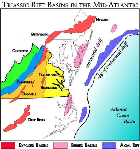 But, second, the Atlantic rifting occurred much farther east than the Protoatlantic rifting. Axial rifts, those that will become an ocean basin, are, naturally, always on the very edge of a continent, and as a result become deeply buried under the divergent continental margin as it develops (Rift cross section #4). On the map, the dark blue fields at the edge of the continental shelf are axial rifts. The axial rift is several hundred kilometers east of the exposed basins, buried under as much as 12 kilometers of continental margin sediments (the edge of the continental shelf, by the way, is the edge of the continent, not the current coast line). So unless some later geologic event brings it to the surface, as with the Proto-Atlantic rift, we will never see it. We do know something of these buried basins from indirect studies, however, discussed in the "Further Details - Buried Basins" section.
The lateral graben are a different story. Unless they become buried under later sediments, they usually remain out and well exposed for all to see, and the U.S. has a rich record of these lateral graben, beginning in New England and running down into the Carolinas. For the most part they are scattered throughout the piedmont province, although a few lie under the coastal plain (map above). The exposed basins along the east coast include the Newark, Gettysburg, Culpepper, Taylorsville, Richmond, Farmville, Danville and Deep Water basins (map), among other lesser ones. Today the remains of the lateral graben are smaller than their original size because erosion has removed parts of them, but they are still a rich record. By a peculiar twist of fate, though, the Culpepper basin from the Atlantic rifting is sitting virtually on top of the Protoatlantic axial rift in the Blue Ridge province. It is one of the special things about Virginia geology that we have so much geology, so far apart in time, but in such close physical proximity. Geology of the Exposed Basins (Lateral Graben) Because the lateral graben are well exposed today we know a lot about them. The basins are typically half-graben, that is a rift valley with a main, or border fault on one side, and the hinge zone on the other side (block diagram). In the Mid-Atlantic the half graben have the main fault on the west, and the hinge on the east. This is the expected orientation, but pecularly, some of the New England graben are reversed; the main fault is on the east and the hinge on the west. In the real world things are never as easy as they seem in theory. Most of the graben are located in the piedmont and so, for the most part, are faulted into igneous and metamorphic basement rocks, including Grenville basement on the far west, and the volcanic arcs and other terrane rocks which came to North America during the Paleozoic Taconic and Acadian orogenies (Piedmont terrane map). 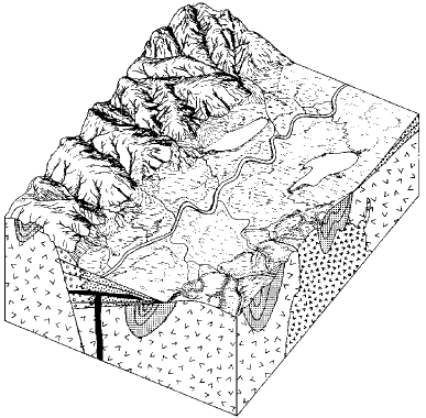 The general development of a lateral graben begins with initiation of the border fault during which the horst lifts, the graben drops, and the hinge zone rotates to allow the half graben to form. The result is a long scarp along one side of a long valley, and the creation of considerable relief.
Sometimes people ask, "Did the horst go up, or the graben down?" Locally, it does not matter; the motion is relative; the only thing the local geology recognizes is that there is relief; a horst to erode and a graben to receive the sediment. But on a regional scale the answer is, "both." The faults develop ultimately because the whole region is being heated by the hot spots and uplifted into a broad plateau several kilometers above sea level. But, as the area swells upward it also stretches at the surface. The brittle rocks crack, form normal faults, and the graben drop down to a lower elevation (rift cross sections #1 and #2). This motion, by the way, is not sudden, but takes place in stages over tens of thousands of years; "Further Details - Exposed Basins" Sediments begin eroding from the horsts almost immediately and flow into the graben (called the basin from now on). Along the base of the fault alluvial fans and rivers deposit gravels and sands. The gravels are without structure implying they were deposited as debris or mud flows (behaving like the concrete coming out the back of a cement truck). The gravel in the conglomerate is made of fragments of the basement rocks forming the horsts. 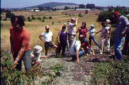 The image to the right is just outside the Culpepper, Va. city limits looking eastward. The border fault and horst would have been just behind us a few yards; it is of course now eroded, with virtually nothing to tell you it was there, except the rocks. If you did not know what you were looking for you could walk right across the fault from the horst into the basin and never know it. The outcrop everyone is standing on is composed of alluvial fan gravel with particles several inches in diameter.
 Eastward, toward the basin center, the alluvial fans interbed with and grade into cross bedded braided and meandering river sandstones, and these finally dump into lake and mudflat deposits (block diagram). Lakes are common because the dropping graben create depressions rivers flow into, but can't get out of. The lakes are characterized by interbedded siltstones and shales, often mud cracked and soft sediment deformed, and typically red indicating good oxygen circulation, but sometimes gray-green due to deposition in stagnant water. 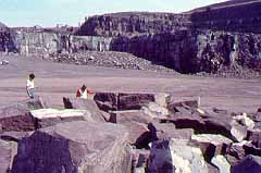 Frequently the river sandstones and lake silts and shales cycle with each other indicating that lake level rose and fell on a regular basis, probably because of long term changes in weather cycles ("Further Details" - paleoclimates). Reptile footprints, including those of early dinosarus, are common on the mudflats. The quarry in the picture to the right has all of these (picture taken several miles east of the above photo, off of Rt. 3 on the way from Culpepper to Fredrickburg, Va.).
So far our discussion has implied that processes in the Triassic basins were pretty straight forward. Hot spots cause the area to swell upward, horsts and graben form, and the graben fill with sediments; end of story. But there are other changes taking place during this time that create an image of the Mid-Atlantic that is not what we might expect. Early in the basin history coal deposits are fairly common in the Virginia basins ("Further Details - Coal Deposits"), and even supported a coal mining industry for a while. They indicate that the area was humid, with abundant vegetation growing in the swamps and along the river edges. But by the end of the rifting event Virginia may have looked more like the areas around Las Vegas or Reno, Nevada than here; dry and barren with only scatterd scrub vegetation, as evaporite deposits accumulated in the basins. The evidence for this transition involves more than we will do here, but the "Further Details - Paleoclimates" page explores it more fully. Igneous Intrusions at the End of the Basin History 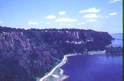 During the later stages of basin history the Triassic and lower Jurassic sedimentary rocks are invaded by igneous magmas and lava flows (block diagram.) This picture of the Pallisades sill along the Hudson river across from New York City is an especially large intrusion, originally formed far below ground, but now exposed by erosion. Related, but smaller, intrusions are found throughout the Mid-Atlantic. In the picture of the alluvial fan gravels above, the hill in the distance is underlain by one of these intrustions.
 The larger intrusions metamorphosed the surrounding sediments, baking them into red hornfels. The red crushed stone used in central Virginia comes from the Triassic sediments in the Culpepper region baked by a nearby igneous intrusion. This episode of igneous invasion accompanies the initiation of Atlantic oceanic lithosphere formation as the axial rift, now buried in the subsurface off the modern coast (map), shears and splits. From this point on the Atlantic ocean basin opens quickly, and as it does the new continental margin cools and sinks below sea level leading to the modern divergent continental margin (coastal plain), which is the next stage.
|