STOP 1 - TRIP TWO
( Next Stop) ( Previous Stop) ( Index Map) ( Trip 2 Home) ( Trip 1 Home)
Brocks Gap - Late Ordovician through Early Silurian
Geology 364 - Stratigraphy and Basin Analysis
Dept. of Geology and Environmental Studies
James Madison University
Lynn S. Fichter
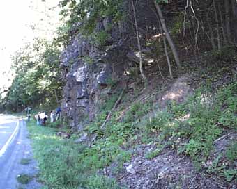
The right picture is a view of Brocks Gap before they came in and blasted the hell out of it to make the road safe. It was a beautiful outcrop, even if it did hang over the highway. The next picture down is the outcrop today. Not as spectacular, but a lot more information accessible
Brocks Gap is a wonderful outcrop that begins in the Reedsville formation and progresses continuously through the entire section to the Oriskany at Chimney rock at the other end of the gap. Not all formations are well exposed, however, especially the Silurian and Lower Devonian. Also, before the cut was made safe the Reedsville was not well exposed either; now there is a very good section of it, right side of the next picture.
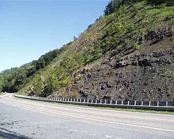 Most of the middle part of the picture, looking covered with green vegetation from this view. is Oswego with what there is of the Juniata and Tuscarora at the far end of the outcrop. The Tuscarora has only a smidge.
The covered Rose Hill followed by the Keefer are then where the trees begin on the left side of the picture.
The two pictures below are close-ups of the Reedsville. On the left is a hummocky sandstone, in which you can barely see some of the hummocky cross laminations. On the right is one of the fossil packstones. Note how rapidly it changes thickness; it is a megaripple, also typical of storm shelves.
|
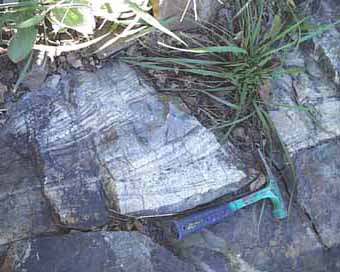
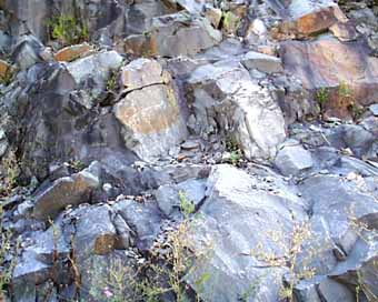 To the right is part of the Oswego, a massive, amalgamated, gray sandstone. It is virtually a quartz arenite, although the black streaks through it sometimes belie that. And there are some lithics in it too.
Sometimes the sands show no structures(are massive), but large scale cross beds of many kinds are common, including both trough and planar cross beds.
|
 More Oswego, with some cross bedding showing up in the upper right of the outcrop.
|
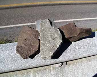 Toward the top of the Oswego some red zones show up. In terms of QFL they are virtually identical to the Oswego, but the rocks have red stain. In thin section the rocks look identical; i.e. the red is such a sparce part of the rock it cannot be detected in the thin section. Here we see a contrast between pieces of the Oswego and the Juniata. Interestingly, both the gray and the red parts occasionally have mud pebbles, and in the gray portions they are gray, and in the red portions they are red. Toward the top of the Oswego some red zones show up. In terms of QFL they are virtually identical to the Oswego, but the rocks have red stain. In thin section the rocks look identical; i.e. the red is such a sparce part of the rock it cannot be detected in the thin section. Here we see a contrast between pieces of the Oswego and the Juniata. Interestingly, both the gray and the red parts occasionally have mud pebbles, and in the gray portions they are gray, and in the red portions they are red.
|
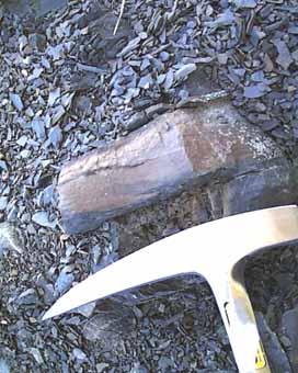
 What there is of the Tuscarora is not much, and not confident. At the very top of the exposed section is a sandstone whose color is going very white; typical of the Tuscarora. But it also has some of the gray streaks typical of the Oswego. It is the best we got for a sample of Tuscarora. Its Massanutten equilalent to the east is of course much thicker, as is the Tuscarora to the west. This is one piece of evidence for the existence of the arch. (This picture is has been rotated to make the rock look right side up; it is overturned in the outcrop you will remember).
The two pictures below are the Keefer. It is a tough, resistent sandstone that stands out boldly. Up in the woods we saw several examples of oscillatory ripples, like the left picture.
|
|
 Most of the middle part of the picture, looking covered with green vegetation from this view. is Oswego with what there is of the Juniata and Tuscarora at the far end of the outcrop. The Tuscarora has only a smidge.

 To the right is part of the Oswego, a massive, amalgamated, gray sandstone. It is virtually a quartz arenite, although the black streaks through it sometimes belie that. And there are some lithics in it too.
  More Oswego, with some cross bedding showing up in the upper right of the outcrop.
 Toward the top of the Oswego some red zones show up. In terms of QFL they are virtually identical to the Oswego, but the rocks have red stain. In thin section the rocks look identical; i.e. the red is such a sparce part of the rock it cannot be detected in the thin section. Here we see a contrast between pieces of the Oswego and the Juniata. Interestingly, both the gray and the red parts occasionally have mud pebbles, and in the gray portions they are gray, and in the red portions they are red.
 What there is of the Tuscarora is not much, and not confident. At the very top of the exposed section is a sandstone whose color is going very white; typical of the Tuscarora. But it also has some of the gray streaks typical of the Oswego. It is the best we got for a sample of Tuscarora. Its Massanutten equilalent to the east is of course much thicker, as is the Tuscarora to the west. This is one piece of evidence for the existence of the arch. (This picture is has been rotated to make the rock look right side up; it is overturned in the outcrop you will remember).