 Rifting Models And the Geologic History of Virginia Introduction to Rifting Models In the past 600 million years the eastern seaboard of North America has experienced two rifting events; that is, the opening of two ocean basins: the Proto-Atlantic (Stage C) and the Atlantic (Stage L). Prior to this there were probably other rifting events. Virginia and the Mid-Atlantic region has a good record of these riftings, even if they are fragmentary and sometimes masked by later events. Discovering and unraveling major geologic events requires having a theoretical model of how these events occur, and the kinds of rocks and structures they generate, so that we will recognize the evidence for what it is when we see it, even if it is fragmentary and masked. Modern models of rifting events are based on a wide diversity of information, from geophysical, to evidence of modern events, to evidence of ancient events. These models specify not only the sequence of events and their timing, but also tell us exactly what evidence is needed to identify an ancient rifting event. It is nice, of course, to have as much evidence as possible, but sometimes if you have just a little of the right evidence that fits unequivocally into the theoretical model the ancient event can be recognized for what it is, and reconstructed. What is more, the theoretical model tells you what further evidence to look for, and where, to bolster the interpretation. Sometimes we have the idea that scientists just go out gathering evidence as best they can, and then try to make sense of it, as best then can. This is never the case. Scientists always have a pretty good idea what they are looking for when they gather data, because they have a theory (a model) that tells them what to look for. And if they find evidence that does not fit their theory then there is a good likelihood that their theory is wrong, and a new one must be devised. The bottom line is, there is no such thing as an unbiased observation. We always know what we want and hope to find in the natural world, although we may be shocked, or pleasantly surprised, to find something different. It is possible to read the geologic history of Virginia (16 page version) without knowing the models we have to explain and make sense of it, but the history is much more meaningful if you know the models exist, and what they say. It is important to remember, however, that a model is just a model, a synthesis, an average, an ideal. The natural world rarely matches a model perfectly and we must be ready to work with a certain amount of divergence from the model. The Rifting Model
Mantle Plumes and Hot SpotsA divergent plate boundary, where two lithospheric plates are separating to create an ocean basin, does not exist naturally. It is created by a rifting process (Stages B and C). When fully developed divergent plate boundaries are always located within and generate ocean basins. As the plates diverge mafic magma oozes up from the mantle below into the crack or rift that opens to form new oceanic lithosphere, the ophiolite suite. In this rifting model we are not interested in the processes occurring along a fully developed oceanic divergent margin. Instead we look at how divergent boundaries are first created during the rifting of a continent. A divergent plate boundary initiates somewhere within a plate, away from the edges. The plate may be a block of continental craton, or a part of ocean basin (cross section). When rifting is complete a new divergent plate boundary and a new ocean basin has been created. The former single plate (or continent) is divided into two plates (or continents). 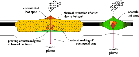 Rifting is initiated by magma plumes rising from deep in the mantle toward the surface. Plumes are randomly distributed over the earth; most arise under a continent or ocean basin, but some may exist at plate boundaries. As the plume rises toward the surface it heats the overlying lithosphere, or rigid outer shell of the earth, causing it to swell upward to create a hot spot. Commonly magma reaches the surface to cause volcanos at the hot spot. The cross section above shows both a continental and an oceanic hot spot. Rifting is initiated by magma plumes rising from deep in the mantle toward the surface. Plumes are randomly distributed over the earth; most arise under a continent or ocean basin, but some may exist at plate boundaries. As the plume rises toward the surface it heats the overlying lithosphere, or rigid outer shell of the earth, causing it to swell upward to create a hot spot. Commonly magma reaches the surface to cause volcanos at the hot spot. The cross section above shows both a continental and an oceanic hot spot.The plumes causing hot spots are stationary in the mantle; unlike the overlying plates that shift continuously plumes do not move. Hence as a plate moves across a hot spot the tectonic and volcanic activity at the surface keeps shifting. Eventually a long string of volcanos may form. The Hawaiian islands are an example of an oceanic hot spot, and Yellowstone Park a continental hot spot. There are many ancient and modern examples of hot spots. Most are isolated and go through their entire history without initiating a rifting event. Sometimes, however, several hot spots join and begin a chain of processes that result in a rifting, a new ocean basin, and a new divergent plate boundary. The processes responsible for this are described below in the next four stages. Hot Spot and Thermal Doming 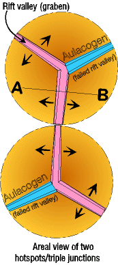 When a mantle plume reaches the base of the continental lithosphere it spreads out creating a pond of magma (see cross section above). The overlying lithosphere heats and swells upward to form the hot spot, about 1000 km in diameter and 3 to 4 km above sea level. The map to the right right shows an areal (airplane) view of two hot spots with triple junctions. When a mantle plume reaches the base of the continental lithosphere it spreads out creating a pond of magma (see cross section above). The overlying lithosphere heats and swells upward to form the hot spot, about 1000 km in diameter and 3 to 4 km above sea level. The map to the right right shows an areal (airplane) view of two hot spots with triple junctions.As the hot spot dome swells its upper surface stretches until the brittle crust cracks (faults) along a series of three rift valleys radiating away from the center of the hot spot. These 3 rift valleys are a triple junction. Ideally the three rift valleys radiate from the center of the hot spot at 120o, but often the triple junction is not symmetrical and arms may diverge at odd angles. The heat from the mantle plume causes a lot of volcanic activity, but it is of two kinds. Pipes of mafic magma (basalt and gabbro) from the ponded plume work their way through the lithosphere, eventually forming volcanoes at the surface. But heat from the plume also warms the base of the continent causing portions of it to melt to form felsic magma (granite and rhyolite), that may also reach the surface to form volcanos. This simultaneous appearance of both mafic and felsic magma is unusual and is called a bimodal association because two markedly different magma types emplace more or less simultaneously. The cross section below is an enlargement along cross section line A-B on the map to the right and shows the swollen hot spot stage with a mafic (basaltic) volcano and felsic (granitic) batholiths. Also observe the faults near the surface and the early horsts and graben. 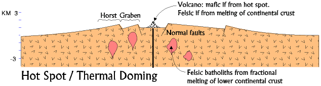 An isolated hot spot may go through all these processes, . . . and then just die. The mantle plume dissipates, the continent cools and sinks again, the volcanic activity stops, and sediments fill in the rift valleys. At the end nothing would be visible at the surface to indicate that the rifts and volcanoes lie buried below the surface. In other situations, however, when several hot spots are closely associated, they may join to form a very long rift valley. For example, the map above shows two triple junctions set to join. If conditions are right these may then initiate the formation of new divergent plate boundaries, and an ocean basin (discussed below). When triple junctions join, only two of the three arms of each triple junction connects with adjacent hot spots. The third arm becomes inactive and is, therefore, called a failed arm (or an aulacogen) (blue on the map above). After rifting is complete and a new ocean basin forms, aulacogens exist like a gash cutting into the continent almost at right angles from the edge. Many ancient aulacogens are known, although most have now filled with sediment and are not observable at the surface. They are good evidence that a hot spot once existed. The sediment and volcanics filling an aulacogen are similar to the processes operating in the active rifts. Foundering of Rift Valley and Marine Invasion Foundering is the collapse of a portion of the earth's surface down to form a depression. Axial rifts are founderings typically tens of kilometers across, with elevations from the rift floor to the mountain crests on either side as much as 4-5 km. 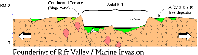 Structurally, rift valleys are block-fault graben (valleys created when a block of the earth sinks), bordered by horst mountains on either side (horsts are blocks of the earth that move up relative to the graben.) If we think about the mechanics of a hot spot, the earth swells upward, causing it to stretch or pull apart across the top. As the earth pulls apart it cracks and leaves space, so naturally a block of the earth will slide down into the space (the graben). The part that does not slide down, the horst, is now higher. Because the earth has already swollen upward with the hot spot it is not necessary for the horsts to move up, but it is easy for the graben to slide down. This process occurs in tens of thousands of tiny steps, each creating a small crack, the sum total of which stretches the earth apart many kilometers. The faults between the horsts and graben are normal faults, normal because it is "normal" for a graben to fall down under gravity. The fault surfaces are curved so that the graben blocks rotate as they subside, trapping small basins where lakes form between the down faulted-block and the wall behind the fault. Many of the lakes are very deep and, based on modern rift lakes, may be extremely salty or alkaline. In the lake bottoms black, organic rich clays accumulate because there is no circulation or oxygen in the deep water. Typically a large number of horsts and graben form, of all sizes. The edges of the major horsts bordering the axial graben are the continental terraces (also called hinge zones). Inside the major axial graben are numerous smaller horsts and graben. 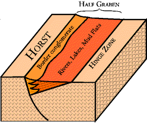 It is also typical for smaller half graben (normal fault on one side only) to form for several hundred kilometers to either side of the axial graben or axial rift (the terms are interchangeable). It is also typical for smaller half graben (normal fault on one side only) to form for several hundred kilometers to either side of the axial graben or axial rift (the terms are interchangeable). Initially the axial valley floor is subareal, that is above water (except for lakes), but as the axial graben subsides the sea invades creating a narrow marine basin (making it subaqueous). A modern example of a rift in this stage is the Red Sea. The horst mountain highlands that border the rift valleys are composed of felsic igneous continental rocks (granites) that erode rapidly to coarse arkosic (feldspar rich) sediments. Most of the sediments are deposited in short systems where environments change rapidly from terrestrial to deep marine. All around the basin edges, at the base of the faults, the sediments accumulate in steep-faced alluvial fans that rapidly change into braided rivers, and then dump into submarine fans. The basin center is frequently deep and anoxic, and thinly laminated black clays and silts are deposited. Thousands of meters of sediment may accumulate during this stage. Igneous activity is very common during this stage, and volcanics and lava flows, sometimes mafic, sometimes felsic, may interlayer with the sediments. The volcanics may be pyroclastic (blasted out of exploding volcanos), or quieter flows. The flows may accumulate thousands of feet thick however. Pillow basalts that form from under water are not unusual. In a geologically short time (~ 10 million years) the horsts are eroded and the graben filled with sediment. As the former great relief (difference in elevation) diminishes the topography smooths out, and the ocean begins to cover the region. Early Divergent Margin 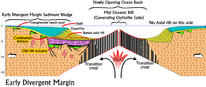 During active rifting the continental crust, heated by the mantle plume, stretches like pulled taffy (or silly putty) and thins, while the brittle upper layers fault and founder to form the axial rift. The whole thing is being held up by the plume heat, and the ponded mafic magma is much closer to the surface making it easier to erupt. This is a very unstable situation (the whole system would collapse quickly if the heat were removed), and continuing processes just make it more and more unstable.
As a result, shortly after the sea floods the axial rift, a great surge of mafic volcanic activity begins along one side of the axial rift. The magma is at first injected into the granitic continental crust as uncountable basaltic dikes. So many dikes are formed it is hard to decide what the original rocks were. This mixture of granite and injected basalt is transition crust, because it is transitional between continental and oceanic crust (see drawing above). This is the beginning of the final splitting of the original single continent into two, and formation of the a new ocean basin. As volcanic activity continues, the gap between the two new divergent continental margins widens as they separate, and oceanic lithosphere formation begins. Surge after surge of magma rises from a newly forming convection cell and injects into the opening gap. Because this new igneous rock is mafic in composition (basalt near the surface and gabbro at depth), and of high density, it "floats" on the underlying mantle below sea level. This creates the new oceanic lithosphere, called ophiolite suite. At an average rifting rate of about 5 cm/year the two new divergent continental margins can be a thousand kilometers apart in 20 million years. In the rifting process the axial rift is not split in two. Ocean crust initiation takes place on one side or the other of the axial rift. One continent retains the axial graben and the other loses it. The result is an asymmetry to the new continental margins. The margin with the axial rift tends to have a gradual transition to oceanic crust, stepping across the axial rift with its minor horsts and graben. The continent without the axial graben drops off precipitously to oceanic crust. Our model follows the axial graben side on the west (left). Heat and magma rising to the surface from the convection cell remains concentrated at the rifting site in the new ocean basin center. As the ocean basin widens the newly formed continental margins move away from the heat source, and cool. Cool crust is denser than warm crust and soon the continental terrace subsides below sea level. These early stages are the time of most rapid cooling and subsidence. By the time ocean crust formation is well under way the axial and lateral graben are nearly filled with sediment. As the new continental margin subsides relative sea level rises, and the shoreline begins to transgress or migrate across the continental margin. The transgressing sea spreads a layer of pure quartz sand out as a beach deposit blanketing the entire region. The quartz sand is the first clear evidence in the rock record that the continental terrace has subsided below sea level and is stabilizing. As the sea transgresses the sea gets deeper and the beach gives way to a nearshore shelf environment, that then becomes a deep shelf environment. This deposition creates a rapidly seaward-thickening wedge of divergent continental margin (DCM) deposits with a shelf, slope, and rise (see cross section at above). Full Divergent Margin 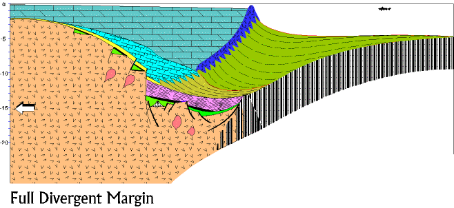 Subsidence due to thermal decay (the loss of heat from the crust and resulting increase in density) is rapid at first, but declines exponentially with time. Divergent continental margins take about 120 million years to reach stability (isostatic equilibrium). Sediment continues to accumulate throughout this time, thickest toward the ocean where subsidence is greatest, and thinning toward the continent. In the end, a sedimentary wedge, 17 kilometers thick at its maximum, is present. Notice in the cross section the volcano that in the hot spot stage was above sea level is now very deep in the earth. The sediment deposited on the divergent continental margin remains mostly shallow-water marine because subsidence and deposition go on at about the same rate. In a warm climate next to a stable craton these may be mostly carbonates (limestones and dolomites), otherwise they are sandstones and shales. If the continental margin stabilizes before something else happens, the sediment just continues to accumulate, but now builds out (progrades) over the ocean floor. This final stage of the rifting will continue indefinitely, or until some other tectonic event intrudes to destroy the quiet divergent margin. |