|
Depositional Environments
In the Catskill Clastic Wedge 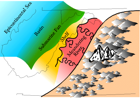 The environments in the clastic wedge exist as a series of belts running parallel to the mountain front. Because the foreland basin shallows toward the southwest and the clastic supply declines, environments change character and diminish in that direction. For example, the Hampshire meandering river environment does not exist farther south than shown on the map. Toward the north the foreland basin deepens, and all the environments shown on the map are well developed there, although the formations have different names. The history of a foreland basin is influenced by two processes, (1) initial rapid basin subsidence, followed by (2) sediment filling the basin from bottom to top. The filling proceeds from proximal (close to the mountain) to distal (away from the mountai). At the more distal reaches the foreland basin merges with the epicontinental sea. This filling sequence is illustrated in a series of cross section on the "History of a Foreland Basin." The environments in the fan include the following. Alluvial Fans/ Braided Rivers: Closest to the mountain we would expect alluvial fans and braided rivers in the Catskill clastic wedge, but these environments are not preserved in Virginia and West Virginia. Likely there were present in the far east but have been lost through later erosion.  Meandering River: More distally (farther away from the mountain) meandering river environments exist, and are well preserved in the Hampshire formation. These rivers finally carried the eroded sediment down to the coast, dumping it on the shelf.
Notice, by the way, that in the Catskill foreland basin a beach environment is not present. This reason for this is explored at this link. Shelf: the shelf environment (Foreknobs formation), at first, near the mountain, was probably not that wide. But as the foreland basin filled the shelf environment widened progressively. Still, the shelf may not have been more than a few miles wide at any one time; nothing like the 10's of miles width for the modern Atlantic shelf. Submarine Fan/Basin: The shelf probably deepened rapidly in its more distal reaches, before steeply descending down the slope toward the submarine fan (Brallier formation) and basin (Needmore formation initially, later Millboro formation). All the environments in the clastic wedge prograded (built out) toward the northwest into the foreland basin from the mountains in the southeast. Two processes operate during this. First, each environmental belt gets wider, and second, each more distal environment tends to get buried under the environment prograding behind it (see cross section below; notice the yellow builds out over the green and the red builds out over the yellow). For example, it is almost as if the meandering river deposits get poured out by the flooding rivers across the shelf environment, not only burying the proximal shelf, but also widening the meandering environment. In time, however, the foreland basin begins to fill, and as it does so some environments become less viable (for example, in Stage V in the foreland basin development both the basin and the submarine fan are no longer viable). The basin, for example, will disappear under the accumulating submarine, shelf, and meandering river deposits. And eventually the submarine fan will disappear as the water becomes too shallow for the turbidity currents to form.  NW-SE Cross Section Through
The Catskill Foreland Basin 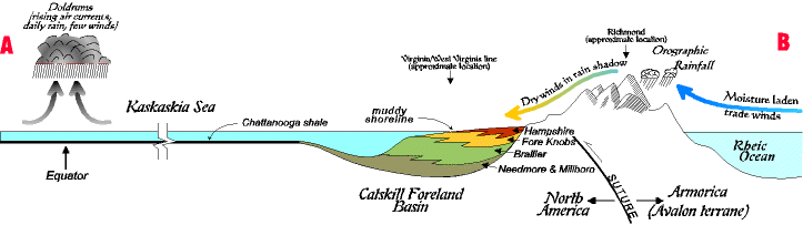 Stratigraphy of the Mid-Upper Devonian in
Western Virginia and Eastern West Virginia 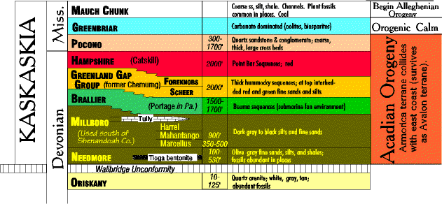 |