|
Interpretation of the Depositional Environments In the Foreknobs (Shelf) and Hampshire (Meandering River/Alluvial Plain) Formations of the Catskill Clastic Wedge
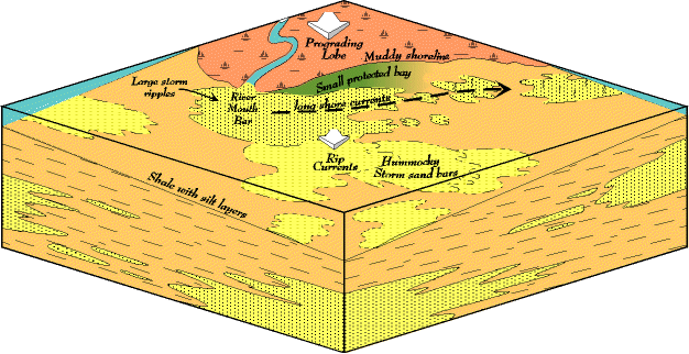 Interpreting sedimentary depositional environments, like all geologic interpretation, is a sophisticated skill drawing on large amounts of information, both theoretical and from the rocks. But we have come a long way in the past 20 years in our abilities to make interpretations. The interpretation below is based not only on the work of others in the Appalachians, but also on detailed analysis of rocks in Virginia and along the Allegheny Front in West Virginia. No analysis or justification is offered here for this interpretation, and little direct evidence, but it captures what the Catskill shoreline may have been like in the Devonian. The Catskill shoreline is built by numerous small sluggish meandering rivers (Hampshire formation; reddish in the block diagram) bringing wacke sediments (mixed sand/silt/clay) down to the coast. The rivers dump their sediment as river mouth bars. Not enough sediment comes down to construct deltas, but the rivers/alluvial plains do, during floods, build lobes that prograde (build out) onto the near shore shelf beyond the rest of the coastline. These progradations take place through numerous flood events, each pushing the coastline out a little. The result is an undulating coast line with river-built lobes alternating with embayments. The coastal plain is in a semiarid climate created by the rain shadow of the Acadian mountains so river flow may be ephemeral (dry most of the year, filled with water only during floods), or just sluggish. Because the region tends to be dry and well drained the alluvial plain sediments are well oxidized, and a deep red in the rock record. No beaches are present along the coast. That is, no clean, well washed sandstone bodies like we find along the Atlantic coast today. This results from very little wave action along the Devonian coast so the wacke sediments on the shoreline do not have a chance to be sorted and cleaned up to form beach sand. Instead the coastline is a "muddy shoreline" (actually a mixture of mud, silt, and fine sand) extending right down to the water, something like the muddy edge of a pond, only this muddy shoreline extends at least from Pennsylvania down to Virginia. Root traces in these red "muds" indicate the presence of low vegetation. So, on an average day, standing on the Devonian shoreline, the sea would be calm and placid. At best there would be small waves generated by whatever gentle winds there were, and we have evidence of this in the occasional oscillation ripples in the red shoreline fine sands. But overall, current ripples and small cross beds indicating fair weather waves are very scarce. Storms do occasionally hit the coastline, however, as indicated by the numerous sandbars on the shelf. The storms have a number of effects. Storm waves crashing on the shoreline and river mouth sandbars, work and redistribute the sand. Offshore directed rip currents drag fine sands out onto the shelf with them where waves rework them into the hummocky sand bars (yellow with fine stipple sin the block diagram) so common in the Foreknobs formation (tan in the block diagram). These are not widespread, continuous sand bodies, but smaller, patchy sandstones separated by shelf muds. Size is hard to estimate but the sand bodies may have been up to the size of several football fields, although the further offshore we go the smaller they become. The thousands of hummocky sands preserved in this formation indicate that periodic, even if infrequent, storms are a part of the long term history of the Devonian coast. Water depth changed commonly during this time, but on average was probably not more than a few 10's of feet deep. But the storm waves also create longshore currents that picked up the coarser river mouth bar sands and transport them along the coast. In the process these sands are cleaned up (clay removed) until they are almost pure sand. And by moving down the coast they also build barrier bars separating the embayment from the open sea. These sandbar barriers (yellow with coarse stipple) probably build right up to the sea surface, but do not rise far above the surface. That is, it is not likely we had a barrier island like along the Outer Banks today. The structures in the sand bars consist of single sets of large cross beds, capped by single sets of small current ripples, stacked one on top of the other, over, and over, and over. This pattern indicates that the storms, when they did hit, were not long lived; just enough waves and currents to move the sand a little, cap it off with smaller waves in the waning stages of the storm, before calm settled in again. Likely, the tops of the sand bars were only a few inches below the water level. Small, protected bays (green on block diagram) were trapped between longshore sandbars and the muddy coastline, and these accumulated muds (shales), typically green in color. Occasional rippled sandstones are found in the shales telling us that storm currents passed over the bar top and into the lagoon, but for the most part the bay water was stagnant with little oxygen on the bottom. The rock record also tells us that relative sea level changed continuously during this time. Relative sea level is not necessarily actual sea level. For example, water could shallow because sea level actually rose, or water could shallow because sediment prograded out across the shelf filling it in. It is often difficult or impossible to know which process was operating, so we just look at how water depth changed, regardless of the actual cause. But overall two major patterns in relative sea level occurred. First, there was just a cyclical change in depth, deep to shallow, back to deep, and so on. But superposed over this was also an overall continuous average shallowing as the red terrestrial environments of the Hampshire formation prograded out over the brownish marine environments of the Foreknobs formation (cross section). So, we imagine the coastline shifting out and in, a river lobe building out into the sea, followed by a relative sea level rise and the shelf flooding back in over the red river sediments. And then a river lobe building out again. In and out, in and out through many cycles, the coast line shifts. But with each cycle the average water depth gets shallower. For example, walking up through the stratigraphic section the first cycle may go from very deep shelf to mid-shelf; the next cycle from mid-shelf to nearshore-shelf; the next cycle from near-shore shelf to muddy shoreline; the next cycle from muddy shoreline to fully terrestrial. We can see part of this pattern in the block diagram. At the bottom of the front corner is a coarse sand bar (yellow) representing a near shore environment. But on top of that are some deep shelf shales (brown)as relative sea level rose. But being deposited on top of that are medial hummocky sandbars as relative sea level drops. This environmental reconstruction of the Devonian shoreline is typical of what we find, but there is also endless variation on the theme. Each outcrop seems to have something special and unique about it that increases the richness of our interpretations. And sometimes an outcrop is just bizarre, presenting something so unexpected and different that we are reminded of how wonderful the natural world is. |