 Technical Depth of the History, and
Theoretical Models TECHNICAL DEPTH OF THE HISTORY
Geologic histories are very complicated, and often require a lot of technical knowledge to understand. We are aware that the audience for this geologic history may be anyone from novices with minimal geologic knowledge and only a passing curiosity, to professional geologists who are interested in a lot of technical detail.It is probably impossible to accommodate to this wide a span of interests and backgrounds in one history. We have tried to accommodate in a number of ways. First, the initial One, Two, and 16 page histories tend to be simple and self-contained, they outline the events in the history without a lot of technical terminology. We hope someone without any geological background will be able to read and gain something from them. Second, for those who want more technical information, each of the pages in the 16 page history has links that descend into deeper discussions. Initially many of these pages are incomplete or simply planned, but as time goes by we will add to and descend into greater and greater detail. Third, we will try to link most of the technical terms we do use in the basic histories to either glossaries or to other pages that systematically explore a particular subject. Again, this is an ongoing project that will expand with time. We are aware how annoying it can be to have a page with seemingly every other word underlined and highlighted to be a link; there is always the temptation to follow a link just because it is there. We have tried to make the links as unobtrusive as possible, and eventually would like to have many of them "mouse-overs"; that is, the word does not light up as a link until the mouse crosses it. In the meantime, the pages just have a lot of links even to basic information, like what is a granite, and if you do not need them just pass them by. Fourth, the histories all are imbedded within and draw heavily upon a number of theoretical models in geology, including plate tectonics, rifting and mountain building models, and the Wilson cycle (see below). We have attempted to provide both simple and more detailed descriptions of those models so those who want to learn more, or understand better the underpinnings of the history can get that information. On the other hand, rocks are the evidence on which any geologic history is based, and a full understanding requires being able to read and understand rocks as well as you can read the words on this page. But since that is background many may not have when they come to this history we are planning pages that summarize igneous, sedimentary and metamorphic rocks classification and interpretation, with lots of pictures. At present only the igneous page is available. If you find your interest expanding we encourage you to explore these pages to get background for understanding the geology better.  Geological Evolution of Virginia
THEORETICAL MODELS BEHIND THE HISTORY
Geologic histories do not exist in a vacuum. The scientific world has spent the past couple of hundred years trying to understand the earth and how it works. Somewhere on the order of a million and a half geologic papers have been written in that time, and the rate of publication keeps increasing. Clearly, as with everything else, our ideas have changed in that time.For understanding the earth the most significant theory has been plate tectonics, a theory that blossomed into existence beginning in 1968 and was virtually universally accepted by 1975. It profoundly changed the way we look at not only the earth as a whole, but at all the pieces too. Prior to plate tectonic theory we had few models that tried to deal with the world globally, and those that did exist did not capture well how we see the earth today. Mountain building models prior to plate tectonics, for example, were contained within geosynclinal theory and were essentially theories of mountains without a viable mechanism for how they formed. Indeed, much of the 1970's and 1980's mountain building modeling was spend trying to transform geosynclinal theory into plate tectonic theory, a process only slightly successful since these two views see the geologic world very differently. This is an interesting history all its own, but needs to be discussed elsewhere. The question we have is, what premises and theoretical models lie behind the geologic history of Virginia presented here? Much of what is below will be familiar to a geologist, but it is laid out so that a lay person will easily grasp the geological pieces and processes that lie behind the history. Three Premises: We begin with three premises that exist as core truths about the earth and how it works. Premise One: No rock is accidental.
No rock is accidental. No idea in geology is more profound than this; it runs from the center to the whole of geology and influences every subdiscipline of the field. Genuine understanding of the science of geology begins with one's ability to understand and explain why no rock is accidental. It is true because of premise two.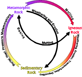 Premise Two: Minerals and rocks are stable only under the conditions at which they form.
All of the rocks and other features on Earth reflect the underlying principle not only of geology but the universe: "minerals and rocks are stable only under the conditions at which they form; change the conditions and the rocks change too to come into equilibrium with the new conditions." Everything strives to come into equilibrium with the existing conditions. Igneous rocks evolve into sedimentary rocks when exposed at the earth's surface, and sedimentary rocks evolve into metamorphic rocks when they are buried deep in the earth, and metamorphic rocks melt to become igneous rocks again when they are hot enough. This concept is contained within the rock cycle. On earth conditions are always changing, leading to premise three. Premise Three: Nothing in geology makes sense except in terms of tectonics. Tectonics is concerned with deformation in the earth and the forces that produce deformation. But why does this deformation take place? The earth is an open system. That is, it dissipates (uses up) energy. The energy comes from the Earth's molten interior (and from the sun), and has kept it tectonically active for 4.5 billion years, and will probably continue for another 4-5 billion years into the future when, finally, the heat supply will run out, and the earth will die. Of course, by that time the sun will enter into its red giant phase and the Earth will be burned to a crisp anyway. But it is this energy from the interior that has driven the Earth's physical/chemical evolution, and been ultimately responsible for all the rocks, continents, mountains, etc. Without it the earth would be like the moon or Mars, geologically and biologically dead, relatively simple, and in equilibrium. The Models: Several models, some nested inside others, are implicit in the geologic history of Virginia. The chart below shows how the models behind the history are related to each other. 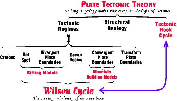 Tectonic models of the earth can be arranged in a hierarchy. Plate Tectonic Theory describes how the earth as a whole works, but directly under that are various subdivisions. These include the 6 tectonic regimes in the chart above, structural geology, and the tectonic rock cycle, among other subjects. The 6 tectonic regimes are the individual pieces and components that make up the earth's rigid outer layer (lithosphere), and interact within plate tectonic theory. Each is characterized by specific processes that generate specific kinds of rocks and structural features. The 6 regimes are not isolated, but interact with each other in complex ways. The Wilson Cycle is the simplest model of those interactions, and a pivotal model behind the Virginia history presented here. Structural geology is a core discipline in geology that describes the way rocks are deformed, and what we can learn from that. Since there are few parts of the earth that have not been deformed a structural analysis is usually the first thing done in a region under study. The tectonic rock cycle is a theory of how earth processes, and specific rocks and tectonic features, are related to each other. We need familiarity with a little of each of these subdivisions to understand Virginia history. Structural geology is a discipline all its own, and we will not review is systematically here. What is needed of structural geology is introduced (pithily) throughout the history. The tectonic rock cycle is a very theoretical formulation, and a separate set of pages exist to explore it. Likewise for the Wilson Cycle (one page version; multiple page version), and rifting and mountain building models. The 6 tectonic regimes are the basic components of all earth models. We refer to them often, and so describe them a little below. Plate Tectonic Theory (link to synopsis) Plate tectonics is the theory that the earth's lithosphere (outer rigid shell) is composed of several dozen "plates", or pieces, that float on a ductile mantle, like slabs of ice on a pond. The plates and their relationships are descibed by the 6 tectonic regimes (below). In plate tectonic theory earth history, at its simplest, is one of plates rifting into pieces diverging apart and new ocean basins being born, followed by motion reversal, convergence back together, subduction of the oceanic crust, plate collision, and mountain building. This cycle of opening and closing ocean basins is the Wilson Cycle . Plate tectonics is one of the great unifying theories in geology. Virtually every part of the earth's crust, and every kind of rock and every kind of geology can be related to the plate tectonic conditions that existed at the time they formed. Nothing in geology makes sense except in terms of plate tectonic theory. Plate Tectonic theory is rather complex, and we develop it just enough for someone to read the Virginia history. A quick and dirty summary of plate tectonic theory is presented in this plate tectonic link; note that there is text below the cross section. Also, see discussion of the tectonic regimes below. The Six Tectonic Regimes The six tectonic regimes are the individual components that interact in plate tectonic theory. They can be grouped into three divisions. Below we briefly describe some important features and facts of each. CONTINENTS AND OCEAN BASINS - divisions that compose the plates. These tend to be big and boring; geologically very little of interest happens within plates. 1. Cratons (stable continents) - those portions of the earth most of us live on. Geologically they are blocks of relatively light weight rock that "float" above sea level on the earth's hot plastic interior. Typically these float no more than a few hundred feet above current sea level, but since sea level rises and falls over time, sometimes sea level is high enough most cratons are below sea level. Modern cratons are, for example, the interior of North America east of the Rocky Mountains and west of the Appalachian mountains (e.g. the mid west), and central and western Australia. Continents are typically sharply separated and distinct from ocean basins, the other major component of the earth's outer shell, on many criteria. The most distinctive is composition. Continents are composed of felsic and intermediate igneous rocks, like granite and diorite, or their metamorphic equivalents, schist and gneiss. They are about 40 km thick. When the earth formed, continents did not exist. They had to be created by processes at convergent plate boundaries (subduction zones), but once formed a continent is more or less permanent. And they tend to grow in size, at least the total mass of continent grows. Individual continents split apart and rejoin all the time in Wilson cycles. The oldest continental fragment is the Slave province in northwest Canada at 3.9 billion years, but continents are still growing today all around the world. 2. Ocean Basins - not everything that is below sea level is ocean basin, but ocean basins are always below sea level. So, when you see a picture of the earth from space, most of that area underwater is ocean basin. The major exceptions are rims of continental shelf around the edges of the continents. Ocean basins compose the largest surface area on earth. As opposed to continents, ocean basins are composed of relatively heavy mafic rocks like basalt and gabbro, heavy enough they "float" on the earth's hot plastic interior about 5.2 kilometers below sea level. Technically, ocean basins are composed of the ophiolite suite, a multilayered sequence of rocks. It is generated at divergent plate boundaries all around the earth, but also disappears down subduction zones at convergent plate boundaries. Unlike continents, ocean basins form and disappear quickly; the oldest we have is only about 200 million years old (compared to the oldest continent at 3.9 billion.) PLATE BOUNDARIES- the three ways plates meet and interact. These areas tend to be long, and linear or gently curved areas that are very unstable. Typically they are only a couple of hundred miles wide, but may be thousands of miles long. Most of what is interesting about the earth happens at these boundaries. The descriptions below are terse. We rely more on illustrations than descriptions. More detailed discussions of the processes happening at the boundaries are explored in the Wilson Cycle and the Tectonic Rock Cycle. 3. Divergent Plate Boundaries - where plates are moving apart and new crust (ophiolite suite) is being created. New ocean crust forms here, and as long as a divergent plate boundary is active an ocean gets wider. 4. Convergent Plate Boundaries - where plates are moving together and crust is being destroyed by descending into subduction zones. Large, explosive volcanos (composite type) are always associated with convergent boundaries. 5. Transform Plate Boundaries - where plates slide past one another. Very interesting geology occurs along transform boundaries, as all the faulting along the San Andreas fault system in California attests to, but they play a small role in most of the models developed here. HOT SPOTS - pretty much do their own thing separate from everything else. 6. Hot spots are isolated, roughly circular, plumes of hot plastic rock that rise from deep in the mantle to the earth's surface. As they rise, they heat the lithosphere, the outer rigid layer of the earth, causing it to swell upward into a dome about 1000 km in diameter and about 4 km high. Volcanic activity is commonly associated with the hot spot. The earth has about 120 hot spots today, and they punch their way to the surface just about randomly, under continents, under ocean basins, and on plate boundaries. Although most hot spots are isolated, when they get together they can create a new divergent plate boundary, and ocean basin. The Wilson Cycle The simplest model for Virginia's geologic history is the Wilson cycle, the opening and closing of an ocean basin. Virginia has experienced parts of at least 2 Wilson cycles during the past billion years and its entire history can be understood in terms of rifting events that tear a supercontinent apart to form a new ocean basin, and subduction and collision events that close the ocean basin again and create new continental crust. This cycle is implicit in the histories to follow, but the cycle is not dealt with directly in the history. A basic understanding of this cycle will go a long way to helping understand the history. Two Wilson Cycle models are available, a single page version, and a multiple page version. The single page version is sufficient for anyone to understand the geological evolution of Virginia. The multiple page version is divided into nine arbitrary stages. It requires a good understanding of igneous, sedimentary, and metamorphic rocks, as well as structural geology. Note that both Wilson Cycle models are simple, ideal models. The earth has many continents, which migrate across its spherical surface in very complex ways. Just about any scenario you can think of, and any exception you can imagine is quite possible - and has probably happened during some point in the earth's history. The Tectonic Rock Cycle The earth, when it originated about 4.5 billion years ago, was composed largely of a single mafic/ultramafic igneous parent rock, just as the moon is today. But while the moon died geologically shortly after its origin (became a closed system), the earth has remained geologically active (an open system). The result is, the earth has evolved, and the most important message of the tectonic rock cycle is that each and every other kind of rock on the earth has evolved from that parent rock. The evolution has taken place through countless Wilson cycles over the past 4 billion years. Through that time, the earth, beginning very simple, has become more and more complex. The rich diversity of rocks form because plate tectonics has created a great diversity of tectonic environments, and each environment generates a specific suite of rocks unique to itself. Wonderful diversity ! The Tectonic Rock Cycle, is the most theoretically abstact and sophisticated model of how rocks and the earth evolve together. It is not for the novice, but its principles lie behind every part of the geological evolution of Virginia. |