|
The Alleghanian Stratigraphic Record
The Stratigraphic History The strata in the Allegheny plateau of southwest Virginia are divided into 15 formation, 8 in the Mississippian and 7 in the Pennsylvanian (stratigraphic column; pdf version). They are thickest to the southeast near the mountain source (5,100 meters) and thin to the northwest. And they represent a major transition in geologic history for this part of the world. Prior to the Alleghanian orogeny marine environments, epicontinental seas and foreland basins, were a prominent feature of our geology. Sediments from the Alleghanian orogeny finally fill these seas in, permanently, and from this time on the eastern interior of North America will not see the sea again. It is this transition we sketch out here. Later we will look closer at the processes and environments in some of the formations to reconstruct in our mind's eye the late Paleozoic world. Throughout much of eastern North America there is a clear break between Mississippian and Pennsylvanian rocks marking the regression of the Kaskaskia sea before the transgression of the Absaroka sea (stratigraphic column; pdf version). But Virginia, laying close to the Alleghanian mountains, received clastic sediment more or less continuously and a sharp break does not occur here, although there still is a minor unconformity. Deposition close to the mountains is also reflected in the complex rock relationships with many interfingering members and diverse depositional processes. The earlier Mississippian formations were deposited at the end of the Acadian orogeny (Price/Pocono and McCrady formations), and in the orogenic calm after the Acadian (Greenbriar). But the later Mississippian Bluefield, Hinton, Princeton, and Bluestone formations mark the initiation of the Alleghanian orogeny (stratigraphic column; pdf version). When mountain building was just beginning depositional environments were dominated by marine shelf and shoreline (beach, lagoon, swamp) environments alternating with each other as fluctuations in sea level, basin sinking, and sediment influx shifted the shoreline back and forth. By the end of the record in the Pennsylvanian terrestrial environments will dominate, first because they are being deposited, and then finally with the unconformity at the top of the section, because they are being eroded. The later Mississippian stage of the Alleghanian orogeny (Bluefield, Hinton, Princeton, Bluestone; pdf) represents the initial Gondwana impact with Virginia, and the beginning of foreland basin subsidence. Note, however, that unlike the Taconic and Acadian orogenies, what develops here is not a rapidly subsiding, deepwater basin. Taconic and Acadian foreland basins begin with black, deep water shales, and develop large submarine fans; there is no hint of either of these in the Alleghanian. The brackish and freshwater swamps in the Bluefield and Hinton, as well as coals and near shore sandbars, will only develop if relative sea level changes slowly. There certainly was basin subsidence, but it was slow enough, and clastic influx high enough, that they were largely in equilibrium. These relationships, along with the rapid sea level changes beginning at this time, produced these abundant coastal environments. So, we have to envision this Mississippian coast line fluctuating back and forth, perhaps on a cycle lasting a few thousand to a few ten's of thousands of years. With each sea level fall coastal and near shore terrestrial environments prograde out into the basin replacing sea with land. And with each sea level rise coastal environments (barrier islands and lagoons with marshes) transgress back toward the mountains replacing land with marine environments. Also, the presence of occasional shallow marine limestones tells us the clastic influx at the beginning was not so high that it just overran the basin, as it does even in the early stages of the Taconic and Acadian. At this Mississippian stage the sea and land are more or less in equilibrium, even if the clastic wedge is beginning to prograde across the relatively stable continental craton. The early Pennsylvanian Lee Group, composed of the Bluestone, Pocahontas, New River, and Norton formations, dominates the middle of the Virginia Alleghanian record (stratigraphic column; pdf version). Here we see the beginning of a major influx of sediments from the mountains as terrestrial environments begin to replace the sea. It is still a time of very rapid relative sea level fluctuations causing rapid shifts in coastal/near shore environments (explored more below), but more and more, distinctly terrestrial environments begin to come in. The Pocahontas formation is the most important coal producer in the region, and its environments have been well studied. We can get some idea of the environmental conditions by looking at models of the paleoenvironments below, one concentrating on the barrier island system, the other on the delta systems. The Barrier Island System 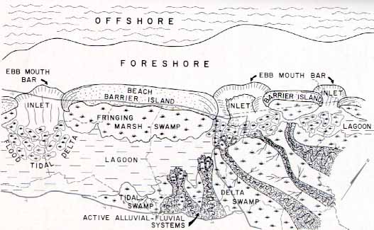 Miller, 1974, DVMR, Bull 84 This drawing cuts across the very southwest portion of the state, Scott, Russell, Tazewell, Lee, Wise, Dickenson, and Buchanan counties (that is the Allegheny plateau region). Northwest is toward the top of the picture, north toward the upper right.Observe at the top the offshore and foreshore regions lying on the edge of the Absaroka sea, and then across the middle and bottom of the picture the beach/barrier islands and lagoon. Also notice the tidal inlets with their flood tidal deltas and ebb mouth bars. If you have any familiarity with the coastal regions of Virginia, or especially the Outer Banks of the Carolinas you have a good feel for what this late Paleozoic world of the Pocahontas was like; they are very similar. Beach/barrier island systems typically develop during a period of sea level rise as waves push sand up into the offshore barrier system. Behind the barrier are the lagoons ("sounds" in east coast terminology) and then the land with its river systems. The inlets are tidal inlets, breaks in the barrier island that allow the tides to flow in an out easily. For the inlet on the left, Oregon Inlet along the Outer Banks of North Carolina would be a good modern representative. But the modern Outer Banks is particularly sparse in tidal inlets because of its low tidal range. Many inlets normally develop well only when tides are higher. Other evidence in West Virginia and west indicates that tides in the Absaroka sea were probably quite substantial, so tidal inlets should be prominent. The fringing marsh/swamp behind the barrier island is the place where most of the coals will form since aquatic vegetation grows well in the shallow water. Again, if you have driven along the outer banks you may have noticed all the vegetation growing on the lagoon side. The drive across the lagoon (sound) from the Outer Banks to Roanoke island especially shows this feature. Year by year vegetation grows, dies, settles below the water into stagnant conditions, and turns to peat. It the peat then gets buried by sediment it will, given enough time and pressure, turn to coal. It takes about 10 feet of peat to produce 1 foot of coal. The modern eastern coastline does not have as many rivers feeding into the lagoon as this model illustrates, but then the modern coast does not have a large, growing mountain range feeding it either. The Delta Systems (under construction) 
We also begin to see in this middle phase (Lee formation) the westward creeping effects of the Alleghanian structural deformation by the presence of the large unconformity between the Pocahontas and New River formations (stratigraphic column; pdf version). Mountain building would have begun in the east, where the first impact was, and then spread inland. We really do not know how fast this occurred, but the presence of broad structural folds in the rocks of the Allegheny plateau tell us that the deformation eventually did get this far, even if it was the last gasps of the orogeny. This unconformity within the Lee probably represents an early pulse of uplift stretching into the plateau region, although the unconformity could also have been influenced by a sea level drop. Indeed, from the New River to the Harlan formations, terrestrial environments increasingly take over the basin. The formations represent the very last marine, shoreline, and nearshore terrestrial rocks to be deposited in western Virginia up to the present day. More and more, land will replace sea until the area is no longer a depositional basin. The New River formation is similar to the Pocahontas formation except that rivers influence it much more, and it has a lot of conglomerate in it that may represent increasing relief in the mountains to the east. But from the Norton to the Gladeville, Wise, and Harlan formations the environments become less dominated by near shore environments and switch to river and flood plain deposits (stratigraphic column; pdf version). Sediment is now actively building the land outward and permanently replacing the Absaroka sea. By the end of deposition of the Harlan formation, Alleghenian deformation finally spreads all the way to southwest Virginia lifting these just deposited formations up as part of the mountain foothills. Then they begin to erode. Rivers cut deep valleys through parts of the Harlan, Wise, Gladenville, Norton, New River, Pocahontas, and Bluestone formations, very far down into the stratigraphic section. From here on western Virginia will remain above sea level and up to the present day be subject to more or less continuous erosion. This late Paleozoic stratigraphic record we have just briefly reviewed is, for its place in geologic history, uniquely special. Prior to this time there has been nothing like it, and to understand it we need to explore a little more closely, to unravel some of the processes operating. Environmental Processes, and Why the Late Paleozoic Stratigraphic Record is Special Geologic history is like a kaleidoscope, there are always patterns, they change continuously, and they never repeat themselves. Depositional patterns in the Late Paleozoic (Pennsylvanian and Permian) are unlike anything that came before, and have not been repeated on their scale since then. Oh, there are many similarities from that time to the present; deltaic environments are still around, and shorelines dominated by beach/barrier islands, lagoons, and tidal marshes, but it is just not the same. What accounts for the great distinctness of the Late Paleozoic? It is the juxtaposition of several factors, all of which are probably necessary to produce this record, and all of which come together here for the first time. One, certainly, is the evolution of a rich, abundant, diverse flora. Plants change the landscape; they allow the development of rich soils, and change patterns of sediment deposition and erosion. Land plants did exist prior to the Pennsylvanian, but were no where nearly as diverse and abundant. A second factor was the volume of clastic sediment spreading across a shallow inland sea. We have had mountain ranges prior to this, and foreland basins to receive the sediment, but these were dominated by steep underwater slopes into deep water, with prominent submarine fans, and narrow shelves. With the Alleghanian orogeny deep foreland basins were not prominent; Gondwana had just slid too far across the edge of North America onto the craton. So, clastic sediment spread into mostly shallow water epicontinental seas on the continents. Prior to this, epicontinental seas were dominated by carbonates (with a few unusual exceptions like the Devonian Chattanooga), with occasional intermixings of shale. Now clastics will just take over. A third factor is sea level changes. Sea level changes all the time, but large changes usually take long spans of time, several 10's to 100's of millions of years, and faster, smaller changes are not that significant. But in the Pennsylvanian this changes. The faster sea level cycles stay fast, but become larger. The result is an unprecedented number of sea level fluctuations that cover and expose large areas of the low lying coastal environments. This change is associated with a major glaciation on Gondwana. As the glaciers waxed and waned, sea level rose and fell. And even though North America is tropical during this time, no where near the glaciation, the sea level changes are world wide (eustatic). The result is rapid transgressions (sea migrating over the land area) and regressions (sea washing off the land area). A fourth factor is the exuberant development of deltaic depositional environments. It is not clear why they come along at this time, but deltas are scarce as hen's teeth prior to this time. Their new prominence certainly includes a combination of the first three factors. Abundant vegetation, coupled with large clastic influxes into shallow water, coupled with rapid sea level changes all favor delta formation. Deltas are so important in this part of the history that to understand the geologic record we need to understand deltas. If they are unfamiliar there is a brief discussion below, but for a deeper discussion go to the delta primer, with an example from southwest Virginia (go there). Deltas, Cycles and Cylothems Coal beds are a common marker in Alleghanian stratigraphy. Because coals are economically important they have been extensively studied, and many coal beds have their own names. For example, the Pocahontas coal is the economic heart of southwest Virginia. But southwest Virginia has 120 coal beds, in nine formations, of which 55 are economically importance. Even for a stratigraphic section 3 miles thick, that is a lot of coal beds. The formation of coal beds is mostly associated with deltaic depositional environments. Deltas are sediment accumulations where a river enters the sea, and as the Greek letter implies, often have a roughly delta (triangular) shape as they spread out into the sea. Deltas also have a life cycle, usually lasting about a hundred years or so. Deltas begin with an active phase when they build out into the sea, followed by an abandonment phase when the river shifts its course, empties somewhere else along the coast, and quits feeding them sediment. After abandonment, the old delta sinks below sea level (i.e. the sea transgresses across it), a coal beds develops on top as a cap, and finally marine sediments bury it. 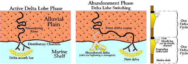 Abandonment of one delta, however, means creation of another delta down the coast somewhere at the new river mouth. This delta switching pattern goes on continuously, all up and down the coast line. A delta is active for a while, abandoned, the marine shale moves in, and then some time later, with another river switch, another delta builds right over the older, and now buried, one. This delta switching pattern, along with the rapid sea level fluctuations produces a cyclical pattern in the stratigraphic column called cyclothems, and it shows up most pointedly as the 120 coal beds capping each delta in southwest Virginia. If we were to drill a hole straight down vertically through a delta it would pass through delta, after delta, after delta, and coal, after coal, after coal. The cyclothems are one of the most distinctive, prominent things about Pennsylvanian rocks. Some of the Virginia coal beds are found in Mississippian formations, but the Pennsylvanian Pocahontas, New River, Norton, and Wise formations contain most of the coal reserves (stratigraphic column, pdf color version). Note that any one formation contains more than one coal bed, that is, more than one delta cycle, so the stratigraphic column, for all its seeming complexity, is still a very generalized look at the southwest stratigraphy. But more than this is more than we can pursue here.
|