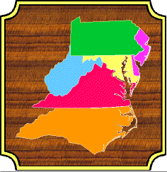
 Geological Evolution of Virginia and the Mid-Atlantic Region
Detail Pages Cross Section J (Next Cross Section) (Previous Cross Section) (Home) The Devonian Acadian Orogeny Middle to Late Devonian; 380 - 350 mya Supporting Pages: Four pages containing maps, cross sections, block diagrams, etc. support the Acadian orogeny. They are all linked together, and to appropriate places in the main and detail pages, but are listed here for convenience. Reconstructing the Ancient Environments the storm shelf, the muddy shoreline, the stagnant sea bottom Many interesting things happen during deposition of the Catskill clastic wedge. But always one thing we want to do is reconstruct a picture of what the world looked like if we could have stood there at that ancient place and looked around. We explore three case studies to capture the flavor of the environments in the Mid-Atlantic during the Acadian. Storms in the Foreland Basin. (Foreknobs shelf environment) 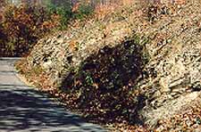 The Foreknobs formation contains the shelf deposits of the clastic wedge. It is filled with thousands of sandstone beds stacked on on top of the other, like the ones to the left, containing hummocky sequences, each one the result of a storm, like a hurricane or, on our modern Atlantic coast, a "nor'easter". Thousands of sandstones means thousands of storms, but just how frequent is that? Do all these sandstone deposits laid out one after the other in the rock record imply that this was a continuously roiled up and riled coastline being pounded incessantly with storms, and little else happening in between?
 To get an answer to this we can use storms on a modern shelf as a model. For reasons that will become clear below, the modern Atlantic coast is not necessarily a good model for the Catskill, but it is familiar to most of us and will give some idea of what we might expect. Every year there is a hurricane season, and anywhere from a few to a few dozen hurricanes are born and wander their way across the oceans. But as most of us know, any one spot of coastline does not feel the impact of all these storms. Indeed, a spot of coast may go for a decade, or many decades, without having any significant storms attack it (like the Carolina Outer Banks recently). So, what is being deposited on the shelf during all these quiet years? Practically nothing, or perhaps a few millimeters of mud washed down with the rivers. But, then comes the big storm that just happens to hit this particular spot on the coast. The wind howls and waves crash with great energy, ripping and eroding the sand, transporting some of it offshore. And there the waves work the sand beds into sandbars with hummocky sequences, the signature of a storm deposit. And then all goes quiet again for another decade, or more. The point is, even though there are many storms each year any one spot of coast receives a major storm infrequently. And the major storms probably crossed any one point on this Devonian Foreknobs shelf no more frequently than they cross the Atlantic shelf today. Yet it is possible to be fooled when looking at an outcrop of rock; sandstone after sandstone seems to point to storm after storm, as indeed it does, but the outcrop skews our sense of time. Each sandstone is probably the result of at most only a few day of strong wave action, while the shale in between represents years of slow, quiet accumulation. And most days of the year produce no rock record at all. The geologic record is, in fact, mostly gaps. So, now imagine the sea to the west in the Devonian being pounded occasionally by large storms. But it is not quite that simple. Shorelines in the Clastic Wedge (Foreknobs to Hampshire transition) The second thing we observe about the clastic wedge is the transition from the Foreknobs shelf to the Hampshire meandering river (environmental map). Normally, a transition from a marine environment to a river environment is marked by a beach environment. Just look all up and down the Atlantic coastline today; beaches everywhere. And we all know what beaches look like; lots of clean, white sand. And, we know well what beaches look like in the stratigraphic record, lots of clean white sandstone, containing other features distinctive of beaches. There are a number of beaches in the Virginia record: the Antietam, Tuscarora, and Oriskany are all beach deposits. But when we walk across this shelf (Foreknobs) to terrestrial (Hampshire) transition anywhere in the clastic wedge there is no beach sand to be found. A beach is clearly absent. 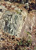 What does it mean, "the beach is absent?" If there is no beach, what is there? What the record tells us is that if you could have stood on that Devonian shoreline what you would see is - mud, a muddy shoreline. Instead of the sandy beach we are used to it would perhaps be more like the edge of a quiet pond, and probably covered with lots of low vegetation. The left picture, for example, is the shoreline preserved near Spruce Knob, West Virginia. The red silts/shales to the right are the muddy shoreline. The sandstone to the left is an offshore sandbar. Below these units the record is dominantly marine, and above terrestrial. No deposits at this outcrop have sand beach features.
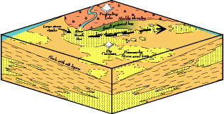 What does a muddy shoreline tell us about the Devonian coastline? Most of us are familiar with the beach, and most of the time what we see are waves. Lots of waves. It is the constant beating of all this wave energy on the coast that works and reworks the sediment brought down by the rivers, sorting out the mud, and leaving on the shore - the sand. The mud in the meantime drifts off shore where it settles out in the quieter water of the shelf.
 And it is not that the sand is just absent in the Devonian; offshore on the shelf, in the Foreknobs formation, are many sandbars (click above picture for enlargement and discussion). What all this tells us is that this coastline received very little wave action. It was still and calm most days of the year. Yes, occasionally a major storm impinged on the coast, the hummocky sandstones in the Foreknobs tells us that, but most of the time it was very quiet. What kind of coast receives little or no wave action? Either one in which no winds blow at all, or one in which the winds blow preferentially from the land toward the sea. We saw in the paleoclimatic reconstruction on the main page that because of the way the Acadian mountains were position relative to the trade winds, that winds likely blew preferentially from land to sea. No waves, no washing of the sediment; no washing of the sediment, no beach sands - a muddy shoreline. The Chattanooga Shale and the Kaskaskia Sea There is one final intriguing mystery associated with all this we want to explore. Perhaps the strangest thing about the mid-late Devonian is what happened out in the Kaskaskia epicontinental sea. Spread across large regions of the continent is a thin (10's of feet), black shale best known as the Chattanooga (but in other places the Albany shale, Cleveland shale, etc.). This shale, when fresh, is the blackest black you can imagine, and where it weathers out it is encrusted with white and yellow salts. And when you walk across pieces of it laying on the ground it often crunches like parchment. What is more the Chattanooga has very high concentrations of uranium, as well as phosphorous. A uniquely distinctive formation. 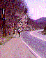 The Chattanooga has all the earmarks of a very deep water deposit, but that just does not make sense. First of all it is just too widespread across the continent, and we know continents float relatively high on the mantle. Even at the height of the Kaskaskia the water was probably not that deep. Besides both below and above the Chattanooga are shallow water deposits, carbonates, in fact.
 So, what is required to get a formation such as the Chattanooga are stagnant conditions, lasting about 20 million years, developing in shallow water, across most of a continent. Normally what keeps a shallow bottom well oxygenated are lots of currents generated by strong waves. And that is the key to the puzzle, for if we look at the "Old Red" map we see just off the coast of the Acadian mountains the doldrums of the equatorial region. The doldrums are well known as a place of few winds and great calm. No winds, no waves; no waves, no strong currents; no strong currents, stagnant bottom. And the way the Old Red continent is positioned these conditions would have been very wide spread across North America. But what about the uranium and other salts? Where do they come from? Actually, it is not that difficult. There exist today, and no doubt in the past, bacteria that scavenge dissolved uranium out of sea water. Just because the bottom of the Kaskaskia is stagnant does not mean the surface is, and in the tropical sun all kinds of algae and bacteria would have thrived there. The uranium-scavenging bacteria concentrate the uranium in their cells, and when they die they sink to the bottom. Because the conditions are so stagnant the normal decay processes are arrested and the uranium just sits there. And because the shale accumulates very slowly, and there is so little of it, the uranium and other salts accumulating over a few 10's of million years become highly concentrated. Similar processes are occurring in the Black Sea today, and there is one ancient example where uranium became concentrated enough to reach critical mass and begin a chain reaction; a natural nuclear reactor. To paraphrase, often times the world is not only stranger than we imagine, it is stranger than we can imagine.
|