 Cross Section
I (Next Cross Section) (Previous Cross Section) (Home) Orogenic Calm in the Central Appalachian Basin Silurian and Early Devonian; 435 - 370 mya 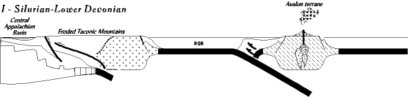 To the west, in western Virginia and West Virginia, the old foreland basins of the Taconic orogeny are now filled with sediment. All that remains is the Tippecanoe, a shallow inland epicontinental sea. The surface of the Tippecanoe sea spreads flat and featureless toward the horizon, but below the surface it is divided into basins (areas where the sea bottom sinks faster, has a thicker accumulation of sediments, and is often deeper water) separated by arches (areas that do not sink but remain near or slightly above sea level, and have a thinner accumulation of sediment). 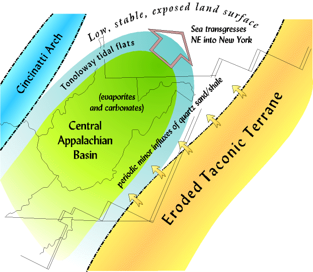 The basin in eastern North America is called the Central Appalachian Basin (CAB). It is an area of mild subsidence trending NE to SW. It is bordered on the west by the Cincinnati arch in central Ohio and Kentucky, while the eastern shore lies somewhere in today's Shenandoah Valley, lapping up onto the edges of the old mountains.
Except when sea level is high, the CAB is mostly a closed inlet, surrounded by low land areas, and isolated from the rest of the Tippecanoe sea. The CAB opens to the rest of the Tippecanoe in the deep south, however, a connection that seemed to persist throughout the period allowing the sea to flow in and out. It might seem that after the complex and interesting Taconic orogeny, this period in history would be boring. But, events occur during the Silurian that are unique in Virginia history, and as fascinating as an orogeny. What is more, these rocks play an important role for both native Americans, and Europeans settling the region (briefly explored below). The Silurian and early Devonian record divides nicely into three phases. Iron in the Clinton and Cayugan The Clinton/Cayugan is deposited just after the Taconic orogeny is over, and as a result contains the last of the clastic sediments to be supplied by the eroded sourceland. The sediments are mostly quartz rich sandstones and shales. And as typical of non-orogenic periods, these do not blanket the CAB but are thin, scattered, patchy deposits that change rapidly from place to place. And the farther west we follow them the more carbonate rich they become. The Cincinnati arch almost never received clastics during this time. The arch was too far west and there were not enough clastics to reach that far. To this point, these features are typical of almost any post-orogenic period. But for reasons not yet clearly understand, a very large volume of iron also came in with the sandstones and shales turning many of the rocks an intense red, a trait more or less true for the Silurian everywhere. It played an important role in European settlement of the region. For the past 2 1/2 millennia civilization has been dependent on iron, but the earth does not offer it up everywhere in useful quantities. Its importance for Colonial America is indicated by the fact that one of the first industries in New England in the 1600's was the Saugus iron works. Iron was essential, and since it was heavy to transport, local sources were sought. Scattered all up and down western Virginia in the Valley and Ridge are the remains of iron foundries, like Elizabeth Furnace, Katherine Furnace, etc. Like the early mills, most of these were destroyed during the Civil War, but for a time they were an important local source of iron. And virtually all of them were based on the Silurian Clinton/Cayugan deposits. Further to the south, in the Birmingham, Alabama area they still support an iron and steel industry. The Salina Salts (link to stratigraphic section) We have mentioned a few times in this history how North America has moved around. In the Cambrian and Ordovician (Stages C and H) the Mid-Atlantic region lay in the trade wind belt, maybe 10-20 degrees below the equator. Places like this today are tropical, usually with steady winds and plenty of rainfall. But by the Silurian North America had drifted a little further south, and the Mid-Atlantic region now lay in the region 25-30 degrees south. That is, in the zone of tropical deserts such as the Sahara. So now you have to imagine standing on the shore of the Central Appalachian Basin, somewhere in western Virginia, looking around. The Taconic peneplain stretches away low, flat, and featureless to the southern horizon (today, east), hidden in a quivering heat mirage. To the north (today, west) the surface of the Tippecanoe sea shimmers in the heat and glare of blazing sun reflecting off the water. And the air is stifling hot, and dry, and the sky clear and cloudless, for Virginia during the Silurian is like the driest, hottest desert you can imagine. The combination of arid climate, tectonic stability, and narrow inland sea partially restricted in its circulation, set up special conditions for sedimentary rock formation. Carbonate deposition dominates around the edges of the basin. The Tonoloway formation is a well known, widespread deposit with abundant tidal features. The Tonoloway contains may of the tidal features we noticed in the Cambrian divergent continental margin tidal formations (Stage E), but here they are much more diminutive, indicating very low, weak tides. These tidal flats extend in a horseshoe shape around the edge of the CAB basin, passing through western Virginia, swinging around in an arc through northern West Virginia, and then coming back down through central Ohio on the Cincinatti arch (CAB map). And as time goes by, and sea level rises, this tidal horseshoe and the sea will transgress northward until it reaches upstate New York. Small patch reefs also dot the area, just off shore from the tidal flats, and the beds around the reefs team with fossils (crinoids, corals, brachiopods, stromatoporoids, etc.) But out in the center of the basin other things are happening. Evaporation is very high, and the reefs prevent easy circulation of the sea water, so a salt brine begins to accumulate. If you have swum in the ocean you know what it is like to swallow a mouthful of salty sea water. During the Salina salt deposition, the salt water in the CAB is much, much saltier. Salty enough that salt crystals grow in crusts on the shoreline and form salt casts in the Tonoloway formation (salt casts are cubic impressions left by halite crystals in the old mud on the sea bottom). Salty enough you would have practically floated on top of the water from its buoyancy. And as the concentration increases it begins to precipitate. The result is a widespread 300-900 foot thick layer of salt deposited in the center of the Central Appalachian Basin. These salts are mostly halite (table salt) and anhydrite (a mineral similar to gypsum) and together are called evaporites. Think about it, a pile of halite and anhydrite hundreds of feet thick stretching from central West Virginia north into Pennsylvania and west into Ohio. Some of these salt deposits also spread south where today the salt comes to the surface around Saltville, Virginia. For millenia these salt deposits have been important to animals, native Americans, and European settlers. The Helderberg Carbonates (link to stratigraphic section) (link to geology of the Smoke Hole region) Salt deposition lasts only through the end of the Silurian. By the early Devonian the Tippecanoe sea begins a major transgression (rise in sea level causing inundation of the land). It spreads up the axis of the CAB toward upstate New York, and no doubt spills over the Cincinnati arch into the epicontinental sea on the other side. This opening breaks the cycle of isolated evaporation in the CAB, and as salinity returns to normal salt deposition stops, and carbonate deposition expands. The Helderberg is a richly fossiliferous deposit stretching from Virginia north through Pennsylvania and into New York. In New York it is well known because it forms the Helderberg escarpment, a distinctive topographic feature. Through far western Virginia and eastern West Virginia the Helderberg is frequently mined for lime and is exposed in numerous quarries. It also has numerous caves in it, avidly explored by generations of spelunkers. A more detailed exploration of this geology can be found at the Smoke Hole ) page. The End of it All: the Oriskany (link to stratigraphic section)  Sea level changes all the time, cycling up and down. And over short intervals of time the changes are not great. But when the land is low and tectonically stable it does not take much change to cover or expose large areas. By the end of the early Devonian sea level had dropped again, resulting in a major regression of the Tippecanoe sea. All of Virginia and North America lies exposed, much as it does today. And, erosion begins to remove some of the rocks deposited in the central Appalachian basin creating the Wallbridge unconformity.
 The Wallbridge unconformity is the boundary between the Tippecanoe sea and the Kaskaskia sea that will shortly begin its transgression, again to put the entire North American continent under a shallow sea by the end of the Devonian. The end of this phase of Virginia's history is marked by the Oriskany formation, a pure quartz sandstone rich in brachiopod fossils. The Oriskany is one of the few times in the history of the Mid-Atlantic when pure quartz sand spreads like a blanket across the region as an indicator of tectonic stability. We have seen two previous ones already, the Antietam in the early Cambrian (Stage C), and the Tuscarora at the end of the Taconic orogeny (Stage H). Sometimes these pure concentrations of quartz are valuable, and the Oriskany is mined all up and down the Appalachians to make glass. But the earth is never still for long, for right on top of the Oriskany is the Needmore formation (link to stratigraphic section), a black, deep water shale. Suddenly, geologically, the earth drops right out from under the Mid-Atlantic region, collapsing it into a deep water basin. Another terrane from out in the ocean is heading our way and will soon collide with and scrape and grind its way all along the eastern coast of North America. The second of the Appalachian orogenies, the Acadian, is about to begin. (Stage J).
|