 Cross Section
E (Next Cross Section) (Previous Cross Section) (Home) The Lower Paleozoic Divergent Continental Margin And the Chopawamsic Volcanic Arc Middle Cambrian and Lower Ordovician; 570 - 490 mya 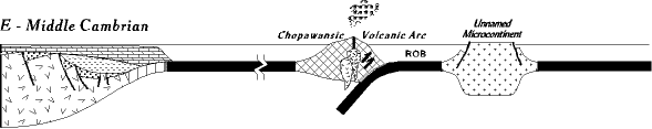 Following the late Proterozoic/early Cambrian rifting a nearly 120 million years period of tectonic quiet settled in along the east coast of North America. During this time the continental edge, subsiding quickly at first and then ever more slowly, continuously accumulated enough sediments to keep the water shallow. The result is a wedge of sediments, thin toward the craton and becoming many kilometers thick toward the Protoatlantic ocean (see above, and rift cross section four). In addition, sea level rose world wide more or less continuously throughout this time, creating in North America what is known as the Sauk sea. Before it was done virtually all of the United States was under water. The only exposed parts were central Canada, and a series of low islands running diagonally from northeast to southwest across the center of the continent known collectively as the transcontinental arch. Take a Cambrian plane trip from Richmond to Reno Nevada and it would have been pretty much water, water everywhere, and not a place to land. 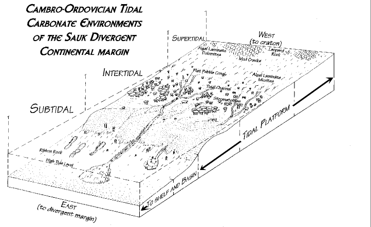 Throughout this time eastern North America lay 20-300 south of the equator. Warm tropical waters, plus an absence of sourcelands to supply sandstones and shales, led to carbonate deposition (limestones and dolomites) many thousands of feet thick. These rocks were deposited in vast tidal flats. The figure to the right (click for larger version) is a model of tidal deposition in the Sauk sea. Tidal environments are divided into three zones: supertidal (above high tide), intertidal (between high and low tide), and subtidal (below lowest low tide). Characteristic processes and deposits occur in each tidal zone, and we have learned to recognize them by studying modern carbonate tidal flats. More about these deposits is explored in the further details link at the bottom. Throughout this time eastern North America lay 20-300 south of the equator. Warm tropical waters, plus an absence of sourcelands to supply sandstones and shales, led to carbonate deposition (limestones and dolomites) many thousands of feet thick. These rocks were deposited in vast tidal flats. The figure to the right (click for larger version) is a model of tidal deposition in the Sauk sea. Tidal environments are divided into three zones: supertidal (above high tide), intertidal (between high and low tide), and subtidal (below lowest low tide). Characteristic processes and deposits occur in each tidal zone, and we have learned to recognize them by studying modern carbonate tidal flats. More about these deposits is explored in the further details link at the bottom. The vast extent of the tidal deposits not only in thickness but existing all across eastern North America tells of large, powerful tides. These existed in part because in the Cambrian the moon was closer to the earth than it is now, and tidal attractions were stronger. We can envision a surge of water, a tidal bore, perhaps several feet high rushing rapidly across western Virginia each day, and then draining off again. These Cambrian and Ordovician carbonate rocks are now exposed throughout the Shenandoah and Page valleys in the Valley and Ridge province, and their extensions north into Maryland's Great Valley, and Pennsylvania. They are largely responsible for the good farmland in these regions. This Lower Paleozoic divergent continental margin will remain tectonically quite through Cross Sections E, F, and G. Each day the tide will move in, and then out, millions of times, then tens of millions of times, and then hundreds of millions of times. Unrelenting boredom. CHOPAWAMSIC VOLCANIC ARC - Fixed and Mobile Worlds Out in the Proto-Atlantic ocean, however, other events are taking place that will eventually become a part of Virginia's history. We observe the beginning of these events with the Chopawamsic volcanic arc in the center of the cross section above. This arc of Middle Cambrian age is now firmly attached to Virginia (located in a narrow strip in the Fredricksburg area in northern Virginia; piedmont belt map), but most of its history took place elsewhere, at least so we now believe. However, prior to plate tectonic theory, when we thought the world was fixed, events in the past had to have pretty much taken place where we find them today. And what this means is that in the Middle Cambrian when western Virginia was a tectonically stable tidal flat, in eastern Virginia violently explosive volcanos of the Chopawamsic arc were spewing out voclanic ash and lava (subduction volcanos are composite types, notoriously the most violent of volcanos). The implications are that these two very different tectonic regimes existed at the same time, and at virtually the same place. Now, this is not impossible, but it requires special pleading, and evidence. Plate tectonic theory has changed all this. Volcanic arcs do not have to remain where they form; in fact it is highly likely they will migrate, at least relatively. For example, look at cross sections D and E for the simple Wilson cycle. The continent on the left and the volcanic arc on the right are moving toward each another as the remnant ocean subducts. But which is really moving? Relatively, it does not matter; they begin widely separated and in time they will collide, and neither will appear to be where they started. With plate tectonics no place is fixed or a fixed reference; all is relative. So, today, instead of presuming that carbonate tidal flats and volcanic arcs exist at the same place at the same time (and if the Cambrian and Ordovician sediments now lying in the subsurface (province cross section) under the Blue Ridge and piedmont are also carbonate, they would have existed at the same place at the same time) it is simpler to assume that the Chopawansic arc began its history somewhere else, and was transported to Virginia later. There is additional evidence to support this, explored in Stage F.
|