|
The Mid-Atlantic Region in the Late Silurian
The late Silurian in the Mid-Atlantic region is tectonically quiet, very hot, and very dry - a tropical desert. To the east lies the old Taconic terrane, now eroded down to a peneplain. Occasionally small amounts of quartz sand or shale erode from it, but otherwise it is too low and stable to be noticed much. To the west, in central Ohio and Kentucky is the Cincinnati arch, a shallower region, occasionally exposed when sea level drops. And in between is the Central Appalachian Basin (CAB), an area of mild subsidence trending NE to SW, lying more or less over the old foreland basins of the Taconic orogeny. The CAB opens to rest of the Tippecanoe epicontinental sea in the southwest, but in the Mid-Atlantic it is mostly a closed inlet. 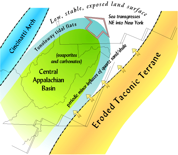 Mostly carbonate sediments accumulate in the CAB in the late Silurian, although at the peak of the heat and dryness hundreds of feet of evaporites, halite and gypsum in the Salina formation, also accumulate because of the high evaporation. And around the edges of the CAB are carbonate tidal flats, the Tonoloway formation. These coastal deposits lap up onto the edge of the eroded Taconic terrane in the east, and the Cincinnati arch in the west, and swing around in a horseshoe shaped arc into Pennsylvania. Relative sea level is low at this time, but in tectonically stable conditions even minor changes in sea level can expose, or cover large areas. But now the sea is rising, and is beginning a transgression that will continue until the coastal regions end up in upstate New York, and the rest of the CAB is under deeper water, and the Helderberg group of carbonate formations. Probably even the Cincinnati arch is under water at the peak. In the east we do not know how much of the Taconic terrane goes under water since the record is not preserved. But most of it could have been inundated. But, the late Silurian is a short interval in a longer period of tectonic calm between the Taconic and Acadian orogenies. At the bottom of the stratigraphic chart we can see the Oswego and Juniata formations that are the last of the Taconic orogeny, and at the top of the chart the Needmore that is the beginning of the Acadian. 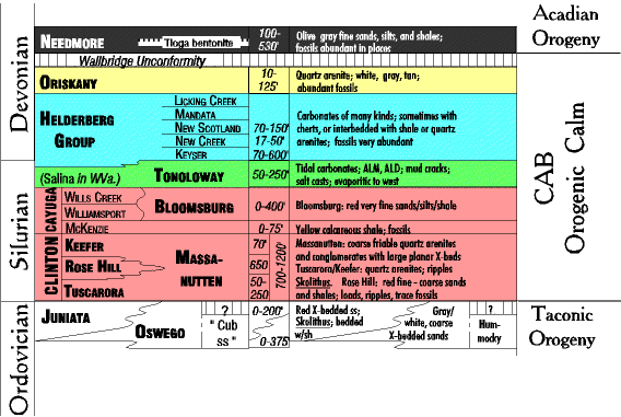 In this overall inter-orogenic interval of tectonic calm the late Silurian is a transition. Below it the Clinton and Cayuga groups are mostly clastic (very quartz rich, but also very iron rich making the rocks deep red), and above it the Helderberg group, abundantly fossiliferous carbonates. But you will notice that most of these formations are not thick (often only 10's of feet), and their geographic distribution tends to be patchy, limited, and change rapidly. This is typical of non-orogenic intervals. Formations deposited during an orogeny tend to be quite thick (hundreds to thousands of feet), and geographically widespread. |