| Home | Intro | PlatTect | IgRx | Physio.Map | X-sections | 1 Page - H | 2 Page - H | 16 Page - H | Wilson Cycle |
|
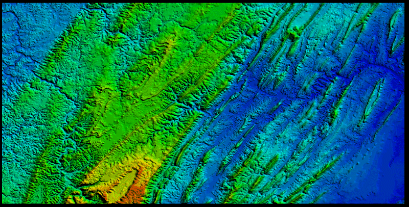
Satellite photo of the Allegheny Plateau (left) and Valley and Ridge provinces in eastern West Virgnina and northwestern Virginia. The colors are coded to elevation. Orange and red are the highest elevations, followed by green, and finally blues as the lowest elevations. The dominatly blue region to the east (right) with green streaks (mountain ridges) running northeast to southwest is the Valley and Ridge. It is underlain by thrust faulted and folded sedimentary rocks. The northeast to southwest linear trends are an expression of the underlying rock structure. The long ridges are held up by erosion-resistant sandstones, while the wide blue valleys are more easily eroded rocks. This region is characterized by a trellis drainage pattern. Trellis drainage is when rivers are forced to run parallel to long ridges, almost like a tree espaliered along a fence. The Allegheny plateau to the west (left) is mostly in green, except in the far west where drops in elevation bring a return to blue colors. Here the rocks are for the most part flat lying. This shows up in the characteristic dendritic drainage pattern (that is, the stream valleys keep splitting and splitting in a random pattern producing stream patterns of no particular orientation. The boundary between the Valley and Ridge and Allegheny Plateau is the Allegheny Front. It shows up as a northeast to southwest linear trend where the color changes from green dominated to blue dominated. At this boundary rock structure changes from folded and faulted to flat lying. |
| |
|||
| Last Update: 9/13/00 | |||