SOME PLATE TECTONIC DEFINITIONS
Plate tectonics is the theory that the earth's lithosphere (outer rigid shell) is composed of several dozen "plates", or pieces, that float on a ductile mantle, like slabs of ice on a pond. The plates and their relationships are descibed by the 6 tectonic regimes: cratons, hot spots, divergent boundaries, ocean basins, convergent boundaries, and transform boundaries (see diagram below).In plate tectonic theory earth history, at its simplest, is one of plates rifting into pieces diverging apart and new ocean basins being born, followed by motion reversal, convergence back together, subduction of the oceanic crust, plate collision, and mountain building. This cycle of opening and closing ocean basins is the Wilson Cycle .
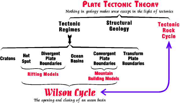
Plate tectonics is one of the great unifying theories in geology. Virtually every part of the earth's crust, and every kind of rock and every kind of geology can be related to the plate tectonic conditions that existed at the time they formed. Nothing in geology makes sense except in terms of plate tectonic theory.
Plate Tectonic theory is rather complex, and we develop it just enough for someone to understand the basics.
The Six Tectonic Regimes
The six tectonic regimes are the individual components that interact in plate tectonic theory. They can be grouped into three divisions. Below we briefly describe some important features and facts of each.
CONTINENTS AND OCEAN BASINS - divisions that compose the plates. These tend to be big and boring; geologically very little of interest happens within plates.
1. Cratons (stable continents) - those portions of the earth most of us live on. Geologically they are blocks of relatively light weight rock that " float" above sea level on the earth's hot plastic interior. Typically these float no more than a few hundred feet above current sea level, but since sea level rises and falls over time, sometimes sea level is high enough most cratons are below sea level. Modern cratons are, for example, the interior of North America east of the Rocky Mountains and west of the Appalachian mountains (e.g. the mid west), and central and western Australia.
Continents are typically sharply separated and distinct from ocean basins, the other major component of the earth's outer shell, on many criteria. The most distinctive is composition. Continents are composed of felsic and intermediate igneous rocks, like granite and diorite, or their metamorphic equivalents, schist and gneiss. They are about 40 km thick.
When the earth formed, continents did not exist. They had to be created by processes at convergent plate boundaries (subduction zones), but once formed a continent is more or less permanent. And they tend to grow in size, at least the total mass of continent grows. Individual continents split apart and rejoin all the time in Wilson cycles. The oldest continental fragment is the Slave province in northwest Canada at 3.9 billion years, but continents are still growing today all around the world.
2. Ocean Basins - not everything that is below sea level is ocean basin, but ocean basins are always below sea level. So, when you see a picture of the earth from space, most of that area underwater is ocean basin. The major exceptions are rims of continental shelf around the edges of the continents.
Ocean basins compose the largest surface area on earth. As opposed to continents, ocean basins are composed of relatively heavy mafic rocks like basalt and gabbro, heavy enough they " float" on the earth's hot plastic interior about 5.2 kilometers below sea level.
Technically, ocean basins are composed of the ophiolite suite, a multilayered sequence of rocks. It is generated at divergent plate boundaries all around the earth, but also disappears down subduction zones at convergent plate boundaries. Unlike continents, ocean basins form and disappear quickly; the oldest we have is only about 200 million years old (compared to the oldest continent at 3.9 billion.)
PLATE BOUNDARIES- the three ways plates meet and interact. These areas tend to be long, and linear or gently curved areas that are very unstable. Typically they are only a couple of hundred miles wide, but may be thousands of miles long. Most of what is interesting about the earth happens at these boundaries. The descriptions below are terse. We rely more on illustrations than descriptions. More detailed discussions of the processes happening at the boundaries are explored in the Wilson Cycle and the Tectonic Rock Cycle.
3. Divergent Plate Boundaries - where plates are moving apart and new crust (ophiolite suite) is being created. New ocean crust forms here, and as long as a divergent plate boundary is active an ocean gets wider.
4. Convergent Plate Boundaries - where plates are moving together and crust is being destroyed by descending into subduction zones. Large, explosive volcanos (composite type) are always associated with convergent boundaries.
5. Transform Plate Boundaries - where plates slide past one another. Very interesting geology occurs along transform boundaries, as all the faulting along the San Andreas fault system in California attests to, but they play a small role in most of the models developed here.
HOT SPOTS - pretty much do their own thing separate from everything else.
6. Hot spots are isolated, roughly circular, plumes of hot plastic rock that rise from deep in the mantle to the earth's surface. As they rise, they heat the lithosphere, the outer rigid layer of the earth, causing it to swell upward into a dome about 1000 km in diameter and about 4 km high. Volcanic activity is commonly associated with the hot spot.