A BRIEF GEOLOGIC HISTORY OF ROCKINGHAM COUNTY

By W. Cullen Sherwood
Dept. of Geology and Environmental Studies
James Madison University


PRESENT DAY GEOLOGIC FEATURES

Perhaps a good way to begin our journey into the geologic past is to look at the major surface features or topography of Rockingham County as it exists today (see Figure 1). This varied landscape results from a combination of three factors: the distribution of the different rock types, the geologic processes of folding and faulting which have deformed these rocks, and lastly the long period of erosion which has worn this area down to its present landscape. Weathering and erosion are the great sculptors of the earth's surface. These processes working over millions of years on rocks of differing resistance are responsible for the landscape we see in Rockingham County today. Figure 1 shows that Rockingham contains four major topographic features: the Blue Ridge Mountains on the east, the Massanutten Mountain in the center, the western ridges (Allegheny Mountains), and the Valley Floor. Although these mountains which reach an elevation exceeding 3000 feet at many points, appear to be separate features, geologists consider all of the mountains in Virginia to be part of the Appalachian Mountain system.

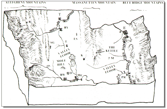
Figure 1. Four major landforms are visible in Rockingham County today. These are 1) The Blue Ridge Mountain to the east, 2) Massanutten Mountain, 3) The Allegheny Mountains to the west and 4) the Valley Floor. Major streams and population centers are also shown. Key to cities and towns: B=Bergton, BW=Bridgewater, BY=Broadway, D=Dayton, E=Elkton, G=Grottoes, H=Harrisonburg, K=Keezletown, L=Linville, LS=Lacey Springs, M=McGaheysville, PR=Port Republic, SG=Singers Glen, T=Timberville.

The Blue Ridge Mountains form a rugged unbroken ridge along the eastern border of the county. This ridge, made up of the oldest and most complex rocks found in the county, separates the Valley of Virginia from the Virginia Piedmont lying to the east. Most of the crest of the Blue Ridge in Rockingham County lies within the Shenandoah National Park. Fine views of both the Valley and the Piedmont are offered by the Skyline Drive which traverses the Blue Ridge crest along the county border (see Gathright-1976).

Massanutten Mountain is a ridge some fifty miles in length which lies entirely in the Shenandoah Valley. However, only the southern end of the mountain lies within Rockingham County where it ends abruptly in a peak visible over most of the region. The rock layers in Massanutten Mountain are folded downward in a "U" shape (called a syncline) which accounts for its peculiar double ridge shape with the kettle area between. Like many of the mountains in western Virginia, the ridges of the Massanutten are capped with a sandstone layer which is resistant to weathering and erosion.

The Allegheny Mountains are a series of ridges and valleys forming the western one-third of Rockingham County. These ridges bear such names as Little North Mountain, Narrow Back Mountain, Feedstone Mountain and Church Mountain. Like the Massanutten, they are usually capped with resistant sandstone rock layers. In general, the rocks of the county become younger toward the west so that the rocks making up the Allegheny Mountains are usually younger than those making up the Blue Ridge and Massanutten Mountains to the east.

The Valley Floor is the gently rolling lowland between the mountains lying at an elevation of approximately 1000 feet above sea level. This lowland forms the central portions of the county and also extends between the Blue Ridge and Massanutten Mountain where it is known locally as Page Valley. The major rocks under the valley floor are limestones and shales. Since limestones and shales erode more rapidly than sandstone, they have gradually been worn down to a lower elevation. S one travels across Rockingham he will encounter a series of northeast trending low ridges (for example Chestnut Ridge just east of Harrisonburg) with many relatively flat areas between. Sinkholes are also common in the Valley area being formed when the roof of a limestone cave collapses leaving a bowl-shaped depression in the land surface. Small, well developed sinkholes can be seen along route 910 west of Harrisonburg and along Old Furnace Road and Route 718 from the Harrisonburg city limits to one mile beyond Cedar Grove Church. Excellent large sinkholes occur just east of and behind Harris Gardens on the Smithland estate, north of Harrisonburg on Route 11.

[Main]  [Introduction]  [Origin of the Major Rocks]