A BRIEF GEOLOGIC HISTORY OF ROCKINGHAM COUNTY

By W. Cullen Sherwood
Dept. of Geology and Environmental Studies
James Madison University


ORIGIN OF THE MAJOR ROCKS

The oldest rocks in Rockingham County are exposed in the Blue Ridge in the vicinity of Swift Run Gap in eastern Rockingham County. These are granite-like rocks which are approximately 1.2 billion years old. The exact origin of these rocks is obscure but they are believed to be part of an ancient mountain system which existed before the present mountains in Virginia. These very old mountains are now mostly eroded away but supplied some of the sediments (sand, silt and clay) which accumulated in layers at the edge of the sea to form many of the rocks presently exposed in the county west of the Blue Ridge. Most geologists believe that these granite rocks of the Blue Ridge, being the oldest rocks in the area, extend down under, and act as a foundation for all of the other rocks in Rockingham County.

The next oldest major rocks in Rockingham formed some 600-700 million years ago as a series of lava flows. These dark colored lavas poured from deep in the earth along huge cracks and flowed layer upon layer burying the old granitic rocks. These flows ultimately reached a thickness of over 2000 feet. During and after cooling, these lava rocks were covered with sea water and over a long period of time were deeply buried under thousands of feet of sediment. Later the lavas were metamorphosed (altered by heat and pressure) to form the Catoctin Greenstone (named for similar rocks in Catoctin Mountain, Maryland). Greenstone is a major rock of the Blue Ridge Mountains. Its distinct bluish-green color is exposed along Route 33 on the west slope of the Blue Ridge to Swift Run Gap, at many points along Skyline Drive, and along secondary roads and trails leading into the Blue Ridge from the west. Spectacular exposures of the greenstone can be seen in the large road cuts along Interstate 64 east of Rockfish Gap near Afton, though these are not in Rockingham County.

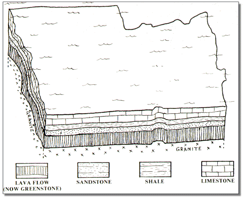
Figure 2. Rockingham County some 350 million years ago. A shallow sea covered this area for approximately 400 million years. As very thick sequence of sedimentary rock layers accumulated under water during this period.

It was probably during the outpouring of these lavas some 600 million years ago that a shallow sea began to spread across Rockingham County and most of eastern North America from what is now present day Canada to Alabama. This sea existed for some 400 million years and was to have a profound effect on Rockingham County geology since the rocks now exposed in the Shenandoah and Page Valley originated here. Into this shallow tropical sea, sediment composed of pieces of sand, mud, silt and clay were carried by rivers draining the continent to the west. Similar material was also being washed from volcanic islands which periodically formed in the sea and were eroded away. Also vast numbers of sea shells of many types were added to the accumulation as millions of generations of sea creatures inhabited the bottom of this warm shallow sea. This allowed a great thickness of sediment, later to become rocks such as standstones, shales and limestones, to accumulate layer upon layer on the sea bottom. This vast blanket of sediment, almost 19 miles thick, is one of the thickest in the world. As the layers accumulated, a very slow sinking of the original sea bottom took place so that the sea was never very deep. Fossils and other evidence point strongly to a shallow-sea origin for the vast majority of the sediments which later hardened to form the limestones, sandstones and shales we see throughout the county today. Figure 2 shows a shallow sea accumulating layer upon layer of sediment.

Of all the rocks exposed in Rockingham County, limestone is perhaps the best known and most important. Two thick sequences of limestone measuring approximately 10,000 feet is one of the thickest known on earth. It is this limestone which underlies most of the valley floor in Rockingham and is a common sight in farmer's fields throughout the Shenandoah Valley. It is of interest that thin layers of volcanic ash are found within these limestone layers indicting that volcanoes somewhere along what is now the east coast of the United States were periodically exploding ash into the atmosphere, much like recent eruptions of Mt. St. Helens. This ash is turn settled to the bottom of the sea and was incorporated into the limestone forming at the time. Two such ash layers are clearly exposed today in the abandoned Betts Quarry just east of Harrisonburg. The younger and thinner sequence of limestone is found only in the Allegheny ridges in the western portion of the county.

Finally as the shallow sea began to recede some 350 million years ago swamps, meandering rivers and dry land began to emerge. The swamps allowed the accumulation of thick peat deposits which were later buried to form coal. These sedimentary rocks, younger than the limestones, are preserved only in the western ridges of the county so that known coal deposits are limited to these western locations also.

[Main]  [Present Day Geologic Features]  [Forming the Mountains]