 Stage H Continent-Continent Collision Mountain Building 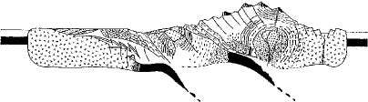 One major difference between this collision orogeny and the Stage F arc-continent collision is that because the hinterland began as a DCM with a thick wedge of sediments it is these DCM rocks that are being thrust toward the foreland (observe that the Eastcontinent DCM of Stage F has been invaded by batholiths in Stage G; after metamorphism the DCM rocks are not symbolized in the drawing.) In the arc-continent collision it is pieces of ocean lithosphere (ophiolite suite) and the volcanic arc that are tbrust toward the foreland. But with the Westcontinent DCM rocks, we would expect ramp and flat thrust faulting to be common, stacking up the sedimentary pile to great thicknesses, as well as large nappe structures. Also observe that the hinterland is overriding not the edge of Westcontinent, but the eastern side of the volcanic arc that collided with Westcontinent in Stage F. But as a result the hinterland is using its weight to shove the arc deep into the earth, resulting in Barrovian metamorphism of the arc rocks. But this is probably not the first time these rocks have been Barrovian metamorphosed, since during the arc's formation much of its deeper portions were metamorphosed by the invation of batholits. [Note, by the way, that in the detailed cross section it is the DCM of a hinterland continent that is being overridden, not a volcanic arc, and it is this sedimentary wedge that would be depressed into the earth and metamorphosed. Many variations are possible on the theme.] Sediments: The sediments eroding from this mountain and filling the foreland basin would also be different in composition from those eroding from an island arc, even if they are deposited in very similar depositional environments. The hinterland rocks consist of large volumes of DCM sedimentary rocks undergoing a second (or third, or fourth) cycle of weathering and erosion. They are quartz rich, as shown in the QFL (blue field). Also, because the source land is complex, the diversity of lithic fragments is great, including sedimentary, metamorphic and igneous rock fragments. Also, feldspar is present due to the weathering and erosion of metamorphic schists and gneisses (most likely Na plagioclase), and eventually exposed batholiths (Na plagioclase and orthoclase). All this is in contrast to the sediments filling the foreland basin of Stage F. Because the hinterland in Stage F was a volcanic arc, the sediments entering the foreland basin were much more volcanic-lithic rich and more quartz poor (QFL, green field), in contrast to the much more quartz rich sediments filling the continent-continent collision foreland basin (QFL blue field). Foreland Basin: Foreland basins are common in the geologic record since much of the earth's history is of volcanic arcs and continents colliding in endless Wilson cycles. So a brief examination of their nature. Foreland Basins develop very rapidly geologically. Just before the collision the foreland is tectonically stable with quartz rich sandstones and limestones being deposited (Stage G or detail of DCM). Then the collision occurs and within a few million years the foreland basin subsides hundreds and then thousands of feet (series of stages). The shape of the basin is usually asymmetrical with the deepest portion closest to the mountain and shallowing toward the foreland continent (detail, Stage II). It is not unusual for the total sedimentary thickness in the basin to be two miles thick. A lot of subsidence, and a lot of sediment. The speed of subsidence can be seen in the rock record. The rocks before the collision are often quartz rich sandstones and limestones, both indicative of tectonic stability. But then right on top of them will be black shales deposited in water hundreds of feet deep. The sediments start to fill in the basin, but for a time basin subsidence and deposition are racing with each other. But as the hinterland overthrust grinds to a halt the subsidence slows and then stops. Now the sediment has a chance to catch up and fill in the basin (detail Stage III, and detail, Stage IV). And fill it in it does, all the way to the top, and beyond. Typically after the deep water black shales come avalanches (turbidity currents) of sediment building submarine fans out onto the basin floor. These may reach several thousand feet thickness, and are largely responsible for filling in most of the basin. But as the water shallows upward the turbidity currents give way to shelf environments. Meanwhile closer to the mountain, thick wedges of terrestrial sediments build out toward the coastline. These begin with alluvial fan and braided river deposits, which eventually give way to meandering rivers that work their way down to the coast. The rivers dump sediment into the shoreline region building land where there was once water. This building of the shoreline out across the basin is called progradation, or a prograding shoreline. In time the shoreline will prograde all the way across the basin, filling it in completely, while the terrestrial sediments will pile up another couple of thousand feet (detail, Stage V). By this time the mountain is mostly gone, eroded down to low hills, most of its rock transferred to the foreland basin. And over the next few million years even these low hills will disappear and the land will be reduced to a peneplain (Wilson Stage I). If you could walk across this land it would look flat and featureless, but underneath lies a lot of historical record. To the east the eroded roots of the mountains exposing their batholith and metamorphic rocks, and to the west a thick wedge of foreland basin sediments, but now all buried in the subsurface. |