Studies involving the geology of the Valley have been undertaken periodically over a period of nearly 150 years. One of the first of these was published by University of Virginia geologist Henry Barton Rogers in 1853. Rogers, who subsequently left the University to found the Massachusetts Institute of Technology, was a keen observer and first described many of the rocks and other geologic features which are available for our study today. Following Rogers' work many studies of the geology of Rockingham have been undertaken. Some of the best known are those by Butts (1940), Brent (1960), and Hack (1965). Recent interest in potential oil and gas deposits in the county has brought in geologists from as far away as Texas. These geologists using space age technology should provide even greater insights and clues to the local geologic past in the months and years ahead.
PRESENT DAY GEOLOGIC FEATURES
Perhaps a good way to begin our journey into the geologic past is to look at the major surface features or topography of Rockingham County as it exists today (see Figure 1). This varied landscape results from a combination of three factors: the distribution of the different rock types, the geologic processes of folding and faulting which have deformed these rocks, and lastly the long period of erosion which has worn this area down to its present landscape. Weathering and erosion are the great sculptors of the earth's surface. These processes working over millions of years on rocks of differing resistance are responsible for the landscape we see in Rockingham County today. Figure 1 shows that Rockingham contains four major topographic features: the Blue Ridge Mountains on the east, the Massanutten Mountain in the center, the western ridges (Allegheny Mountains), and the Valley Floor. Although these mountains which reach an elevation exceeding 3000 feet at many points, appear to be separate features, geologists consider all of the mountains in Virginia to be part of the Appalachian Mountain system.
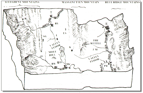 |
| Figure 1. Four major landforms are visible in Rockingham County today. These are 1) The Blue Ridge Mountain to the east, 2) Massanutten Mountain, 3) The Allegheny Mountains to the west and 4) the Valley Floor. Major streams and population centers are also shown. Key to cities and towns: B=Bergton, BW=Bridgewater, BY=Broadway, D=Dayton, E=Elkton, G=Grottoes, H=Harrisonburg, K=Keezletown, L=Linville, LS=Lacey Springs, M=McGaheysville, PR=Port Republic, SG=Singers Glen, T=Timberville. |
The Blue Ridge Mountains form a rugged unbroken ridge along the eastern border of the county. This ridge, made up of the oldest and most complex rocks found in the county, separates the Valley of Virginia from the Virginia Piedmont lying to the east. Most of the crest of the Blue Ridge in Rockingham County lies within the Shenandoah National Park. Fine views of both the Valley and the Piedmont are offered by the Skyline Drive which traverses the Blue Ridge crest along the county border (see Gathright-1976).
Massanutten Mountain is a ridge some fifty miles in length which lies entirely in the Shenandoah Valley. However, only the southern end of the mountain lies within Rockingham County where it ends abruptly in a peak visible over most of the region. The rock layers in Massanutten Mountain are folded downward in a "U" shape (called a syncline) which accounts for its peculiar double ridge shape with the kettle area between. Like many of the mountains in western Virginia, the ridges of the Massanutten are capped with a sandstone layer which is resistant to weathering and erosion.
The Allegheny Mountains are a series of ridges and valleys forming the western one-third of Rockingham County. These ridges bear such names as Little North Mountain, Narrow Back Mountain, Feedstone Mountain and Church Mountain. Like the Massanutten, they are usually capped with resistant sandstone rock layers. In general, the rocks of the county become younger toward the west so that the rocks making up the Allegheny Mountains are usually younger than those making up the Blue Ridge and Massanutten Mountains to the east.
The Valley Floor is the gently rolling lowland between the mountains lying at an elevation of approximately 1000 feet above sea level. This lowland forms the central portions of the county and also extends between the Blue Ridge and Massanutten Mountain where it is known locally as Page Valley. The major rocks under the valley floor are limestones and shales. Since limestones and shales erode more rapidly than sandstone, they have gradually been worn down to a lower elevation. S one travels across Rockingham he will encounter a series of northeast trending low ridges (for example Chestnut Ridge just east of Harrisonburg) with many relatively flat areas between. Sinkholes are also common in the Valley area being formed when the roof of a limestone cave collapses leaving a bowl-shaped depression in the land surface. Small, well developed sinkholes can be seen along route 910 west of Harrisonburg and along Old Furnace Road and Route 718 from the Harrisonburg city limits to one mile beyond Cedar Grove Church. Excellent large sinkholes occur just east of and behind Harris Gardens on the Smithland estate, north of Harrisonburg on Route 11.
|
|
ORIGIN OF THE MAJOR ROCKS
The oldest rocks in Rockingham County are exposed in the Blue Ridge in the vicinity of Swift Run Gap in eastern Rockingham County. These are granite-like rocks which are approximately 1.2 billion years old. The exact origin of these rocks is obscure but they are believed to be part of an ancient mountain system which existed before the present mountains in Virginia. These very old mountains are now mostly eroded away but supplied some of the sediments (sand, silt and clay) which accumulated in layers at the edge of the sea to form many of the rocks presently exposed in the county west of the Blue Ridge. Most geologists believe that these granite rocks of the Blue Ridge, being the oldest rocks in the area, extend down under, and act as a foundation for all of the other rocks in Rockingham County.
The next oldest major rocks in Rockingham formed some 600-700 million years ago as a series of lava flows. These dark colored lavas poured from deep in the earth along huge cracks and flowed layer upon layer burying the old granitic rocks. These flows ultimately reached a thickness of over 2000 feet. During and after cooling, these lava rocks were covered with sea water and over a long period of time were deeply buried under thousands of feet of sediment. Later the lavas were metamorphosed (altered by heat and pressure) to form the Catoctin Greenstone (named for similar rocks in Catoctin Mountain, Maryland). Greenstone is a major rock of the Blue Ridge Mountains. Its distinct bluish-green color is exposed along Route 33 on the west slope of the Blue Ridge to Swift Run Gap, at many points along Skyline Drive, and along secondary roads and trails leading into the Blue Ridge from the west. Spectacular exposures of the greenstone can be seen in the large road cuts along Interstate 64 east of Rockfish Gap near Afton, though these are not in Rockingham County.
 |
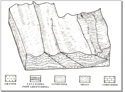
| Figure 2. Rockingham County some 350 million years ago. A shallow sea covered this area for approximately 400 million years. As very thick sequence of sedimentary rock layers accumulated under water during this period. |
It was probably during the outpouring of these lavas some 600 million years ago that a shallow sea began to spread across Rockingham County and most of eastern North America from what is now present day Canada to Alabama. This sea existed for some 400 million years and was to have a profound effect on Rockingham County geology since the rocks now exposed in the Shenandoah and Page Valley originated here. Into this shallow tropical sea, sediment composed of pieces of sand, mud, silt and clay were carried by rivers draining the continent to the west. Similar material was also being washed from volcanic islands which periodically formed in the sea and were eroded away. Also vast numbers of sea shells of many types were added to the accumulation as millions of generations of sea creatures inhabited the bottom of this warm shallow sea. This allowed a great thickness of sediment, later to become rocks such as standstones, shales and limestones, to accumulate layer upon layer on the sea bottom. This vast blanket of sediment, almost 19 miles thick, is one of the thickest in the world. As the layers accumulated, a very slow sinking of the original sea bottom took place so that the sea was never very deep. Fossils and other evidence point strongly to a shallow-sea origin for the vast majority of the sediments which later hardened to form the limestones, sandstones and shales we see throughout the county today. Figure 2 shows a shallow sea accumulating layer upon layer of sediment.
Of all the rocks exposed in Rockingham County, limestone is perhaps the best known and most important. Two thick sequences of limestone measuring approximately 10,000 feet is one of the thickest known on earth. It is this limestone which underlies most of the valley floor in Rockingham and is a common sight in farmer's fields throughout the Shenandoah Valley. It is of interest that thin layers of volcanic ash are found within these limestone layers indicting that volcanoes somewhere along what is now the east coast of the United States were periodically exploding ash into the atmosphere, much like recent eruptions of Mt. St. Helens. This ash is turn settled to the bottom of the sea and was incorporated into the limestone forming at the time. Two such ash layers are clearly exposed today in the abandoned Betts Quarry just east of Harrisonburg. The younger and thinner sequence of limestone is found only in the Allegheny ridges in the western portion of the county.
Finally as the shallow sea began to recede some 350 million years ago swamps, meandering rivers and dry land began to emerge. The swamps allowed the accumulation of thick
peat deposits which were later buried to form coal. These sedimentary rocks, younger than the limestones, are preserved only in the western ridges of the county so that known coal deposits are limited to these western locations also.
|
FORMING THE MOUNTAINS
 |
| Figure 3. A sketch of the major folds and faults in Rockingham County as they may have appeared some 140 million years ago. |
Sometime during the 400 million year period when the shallow seas were accumulating sediment which would later become the major rock layers of the county, a curious thing began to happen. The existing Atlantic Ocean apparently began to shrink bringing Europe and Africa closer to North and South America. Finally, approximately 275 million years ago the Atlantic closed and the continents on either side of the ocean collided, ramming northwest Africa into eastern North America. As the continents collided the rocks along the edges were crumpled and broken forming the Appalachian Mountain system. This collision of the continents had a profound effect throughout the eastern United States. The flat sedimentary layers of rocks deposited in the shallow sea were heaved up, folded and broken (see Figure 3) to form mountains much larger than those existing in Rockingham County today. Indeed most of the present mountains of the eastern United States are believed to be the eroded remnants of the great mountains formed during this collision. Figure 3 is a diagramatic sketch of some of the major folds and breaks (faults) which must have existed in our area at the end of the Appalachian mountain building period some 150 million years ago. These mountains were not formed overnight but were produced aver a period of several millions of years and were being affected by rapid erosion as they were formed. The combined action of crumpling the rock layers and rapid erosion must have produced high, rugged mountains in our area similar to the Alps and the Himalayas of today.
Recent geologic investigations, mostly related to natural gas exploration, have indicated that faulting in the Valley may have been much more intense than was formerly suspected. Apparently in response to the African collision, large slices of rock were broken loose and pushed westward up over other rocks. Some geologists now believe that the Blue Ridge Mountains have been thrust several miles westward up over folded sedimentary rocks similar to those exposed in the valley floor. Drilling planned in this area for natural gas should soon begin to provide some insights into the nature and extent of this faulting and thrusting of the rocks.
|
MOLE HILL AND OTHER MELTED ROCKS
Formation of the mountains left the originally flat layers of Rockingham extensively folded and broken. Avenues of weakness were now available whereby any melted rock material formed at depth in the earth could find its way up to or near the surface. We have good evidence in Rockingham County that several masses of molten (igneous) material did find their way upward into the think overlying sedimentary layers and cooled forming hard rocks. A number of these formerly molten rocks are exposed at the surface in Rockingham County today.
Most igneous rocks found in Rockingham formed as vertical thin tablet-shaped bodies known as dikes. Most are only a few feet thick, and extend downward like a curtain into the earth. These dikes can often be found in the field by looking for brown, rounded rocks on the surface. Two dikes well known to local geologists are located as follows: one just east and almost parallel to Rt. 910 north of Rt. 765 (this dike crosses Rt. 910 just north of Green Mount Church), the other is exposed in the field just east of the Mundy Quarry and west of Rt. 602 in east Rockingham. So far as is known all of the thin dikes or igneous intrusions in the county are composed of a nearly black igneous rock.
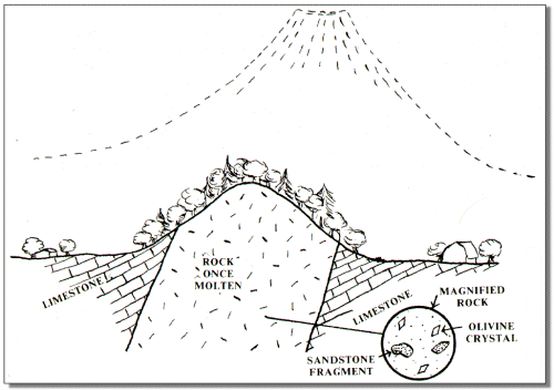 |
| Figure 4. A cut away view of Mole Hill. This magnified view shows the olivine crystals and fragments of sandstone carried upward by the melted rock. Above in dashed lines is a volcano which may have existed millions of years ago but has now been eroded away. |
Probably the most interesting igneous intrusion in Rockingham County is that exposed in Mole Hill located approximately four miles southwest of Harrisonburg near Dale Enterprise (see figure 4).
The rock here is also dark colored with large crystals of the green, glassy mineral known as olivine included in it. Also included in the rock are pieces of sandstone which could only have been picked up thousands of feet down and brought to the surface as the lava flowed upward. Evidence is strong that Mole Hill is the conduit or pipe which fed molten igneous rock to a volcano which has now been eroded away. Recent work by Wampler and Dooley (1975) shows an age of approximately 47 million years for the Mole Hill rocks. This date is considerably younger than the 180 to 230 million year dates formerly attributed to the igneous rocks of the Valley. So at this point we can say that Mole Hill may well have been one of the last volcanoes which existed in what is now Virginia.
|
CAVES AND CAVERNS
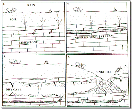 |
| Figure 5. Evolution of cave and sinkhole. 1. Rain soaks through soil and starts to dissolve limestone. 2. Small wet cave carries underground stream. 3. Dry cave forms and groundwater forms another wet cave at a lower level. 4. Cave ceiling collapses forming sinkhole. |
Of all the aspects of Rockingham County geology, probably none are more fascinating than the caves which abound here. Limestones are unique among rocks in having the ability to form caves which carry underground streams. Even a brief look around the Shenandoah Valley will show the observer that very few surface streams exist. The many streams normally found on the surface in other areas run underground in caves here. It is interesting to take a look back in time and see how these caves formed. Over thousands of years, as rain fell and soaked into the ground, it entered cracks in the underlying limestone bedrock and began to dissolve out small channels in the rock. As these channels grew larger, more water could enter the openings and underground cave systems were formed. Some of our caves have active streams flowing in them, while others have become dry as the groundwater forms more channels and moves deeper underground (see Figure 5).
Dry caves with cave formations such as stalactites, stalagmites and columns are among the most beautiful of geological features. Many of the Shenandoah Valley caves have been commercialized and called caverns, but whether called cave or cavern they were formed by the same process. They draw thousands of visitors each year. Many other "wild" caves of near equal beauty occur throughout the limestone areas of the Valley and are known to but a few people. In addition to these dry caves, thousands of smaller wet caves carry much of the ground water available in Rockingham County. Local well drillers report the intersection of small caves to be a common occurrence when drilling in limestone areas. Many of the wells produce water from caves containing underground streams in the limestone.
Some of the older caves in Rockingham County have literally collapsed due to their size. This has occurred as a cave continues to grow larger and larger through time by dissolving away its limestone walls and ceiling. A stage will then be reached when the thin ceiling rock will no longer be able to support the weight of the overlying soil. The ceiling or roof of the cave then collapses and a sinkhole forms at the earth's surface. These depressions then collect surface water from the rain and snow and funnel it into the cave system. Sinkholes are a common sight in Rockingham County. They immediately notify the observer that a cave system has been developed in that area and continues to act as an underground drainage network. Sinkholes, like caves, only occur in limestone, consequently they are good surface indicators of which areas of the county contain limestone bedrock.*
|
EVOLUTION OF TODAY'S LANDSCAPE
 |
| Figure 6. Major landforms and geology of Rockingham County today. Side views are provided along the southern edge and across the middle of the county to show rocks under the surface. |
Figure 6 shows the relationship between today's landscape and the underlying geology. This relationship has evolved over the last 240 million years following the formation of the Appalachian Mountains. During this 240 million years, erosion has been the dominant geologic process at work on the Rockingham landscape. Even though this erosion is slow in human terms, over tens of millions of years it can drastically alter a mountain range or even wear it down to sea level. A look at the rocks making up Rockingham County today in Figure 6 indicates that thousands of feet of rock material have been eroded off and carried away by the rivers to the sea. So we know that our mountains of today such as the Blue Ridge, Massanutten and the Allegheny are mere stumps of former mountains which were originally much larger and more rugged. Areas underlain by hard resistant rocks like sandstone now stand as ridges while areas underlain by softer, less resistant rocks like limestone and shale now exist as valleys.
The most comprehensive study of the present landscape of Rockingham was made by geologist John Hack (1965) of the United States Geological Survey in his report on the geomorphology of the Shenandoah Valley. Hack theorized that the present ridges and valleys were related strongly to the resistance to erosion of the underlying bedrock. So areas with sandstone and greenstone bedrock have resisted erosion and now stand as ridges. Limestone being less resistant to erosion has worn down more rapidly and now forms the major portion of the lowland or valley floor. Hack calls this response a system of "dynamic equilibrium" indicating that erosion continues but the mountains and valleys retain their relative size and position.
Also of interest in Figure 6 are extensive gravel deposits which exist along the edge of the Blue Ridge and Allegheny Mountains. The most extensive of these deposits have been washed out of the Blue Ridge by stream action and have accumulated as thick aprons of loose sand and gravel which become thinner westward, away from the Blue Ridge. Most of the gravel is composed of rounded pieces of hard rock known as quartzite. Rounded pieces of this tan and yellow gravel can easily be seen by even a casual observer in the fields and roadcuts along Highway 340 and nearby secondary roads and along Fulks Run and Briery Branch in the western portion of the county.
The South Fork of the Shenandoah has reworked many of these gravels as it meandered back and forth across its valley through time. This action has resulted in the formation of a series of flat surfaces much like broad stair steps; these flat valley surfaces are called terraces. At many points in the vicinity of Elkton and along Route 340 one can notice the existence of these terraces. In some cases it is possible to look across the river and see a flat area of the same elevations indicating that the gravel layer once extended straight across, but the river has now deepened its valley forming newer flat areas at a lower elevation. Arrow points and other evidence of Indian occupation are commonly found on these terraces.
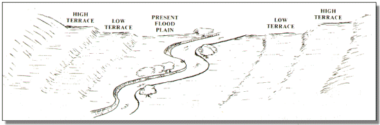 |
| Figure 7. Terraces, like stair steps, represent former floodplains of the River. The river has been cut progressively downward from the high terrace to the low terrace to its present floodplain. Evidence of Indian occupancy is common on the terraces throughout Rockingham County. Portions of present day Elkton, Grottoes, Bridgewater, Broadway and Timberville are also located on terraces. |
Finally, most of the rivers and streams in the county have developed active flood plains of various widths. Flood plains are the flat areas along streams covered by sand and silt deposited when the river is at flood stage. The flood plain often covers hundreds of acres and may cover the bedrock to a depth of several feet or even tens of feet. Flood plains usually make excellent farmland due to the fertile soil and moist conditions. However, building and development in the flood plain is risky and is usually not recommended due to the risk of periodic flooding during high rainfall periods. Figure 7 shows the present flood plain and terraces formed by a river.
|
GEOLOGY AND HUMAN HISTORY IN ROCKINGHAM
There is little question that geology has had a profound effect on human history in Rockingham County. The land use plan for Rockingham County (1975) shows a strong relationship between geology and existing land use. Most fundamental is the concentration of the population on the valley floor with comparatively low population density in the mountainous areas. Two factors are probably of most importance-first, the rich limestone soils and associated flood plain soils drew the early settlers to the Valley because of their agricultural productivity, secondly, the relatively flat valley floor made development of homes, town, and roads relatively easy.
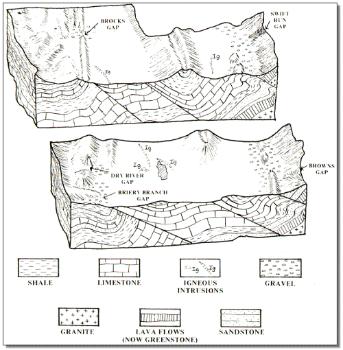
Throughout the history of the Valley, geology has controlled the major travel routes. Indian trails and later roads and railroads have run up and down the Valley since man first moved into and through western Virginia. The route of the early German and Scotch-Irish settlers following the limestones southward from eastern Pennsylvania to the Shenandoah Valley is well documented. The east-west routes across western Virginia have equally important geologic controls. These routes traverse the mountains through the gaps cut by active or formerly active streams. In Rockingham the major east-west highway, Route 33, traverses Swift Run Gap in the Blue Ridge and the Dry River Gap through the ridges in the western portion of the county. Other gaps which have been used for east-west routes in Rockingham are Browns Gap and Simmons Gap in the Blue Ridge and Brocks Gap and Briery Branch Gap to the west. Browns gap in particular was a major route across the Blue Ridge for many years until it was closed to traffic by the formation of the Shenandoah National Park. Many secondary transportation routes show local control by ridges, hills and stream valleys. Finally, the major streams and rivers of the county served as important water transportation routes during the early years of human settlement in the Valley. Much of the early commerce such as lumber, grain, tanning bark, and wool moved down the forks of the Shenandoah river to market and to ports further north and east.
Much of the mountainous area of Rockingham is today in the hands of the federal government. Most of the Blue Ridge lies within the Shenandoah National Park and much of the Massanutten and Allegheny Mountains are in George Washington National Forest. Federal control further restricts population growth in these areas where low population density has always been the rule. That recreation, timber production, and wildlife management comprise the principal land uses at present is due primarily to geologic and topographic limitations of the mountainous areas.
Another human activity in Rockingham which has been significantly affected by geology is the production of useful minerals. This includes present quarrying and mining for sand and gravel, crushed stone, and agricultural lime in several localities. Iron was formerly mined at a number of sites around the county and zinc at two localities near Timberville. Active drilling for natural gas in now underway based on new geologic evidence and some past production near Bergton. Ocre, an iron oxide pigment, occurs at several points within the county and has been mined near Keezletown. According to Brent (1960), coal was briefly mined at Wolf Creek near the Augusta County line and has been found near Rawley Springs and Briery Branch Gap.
Geological features have played a major role in the development of tourism and recreational areas in Rockingham. First and foremost is the generally acknowledged beauty of the mountain and valley scenery of the area. The construction of the Skyline Drive by the federal government attests to this point. Caves developed in the valley limestones have also fascinated Valley visitors for years. Massanutten, Endless, and Melrose Caverns have all been or are now operating as commercial caverns. The large number of non-commercial caves have also brought visitors interested in exploring the underground environment. Skiing, backpacking, hunting, boating and a number of other outdoor activities take advantage of the appropriate geologic features of the county.
In short, many of the diverse activities in which the citizens of Harrisonburg and Rockingham are now involved, in making a living, in providing shelter, in raising food, or in providing recreation are intimately related with the geologic environment. A strong case can usually be made for a relationship between the geologic history of any area and the human history superimposed upon it. The relationship appears to be particularly striking in the case of Rockingham County where both the human history, recorded by man's hand, and geologic history, recorded in the rocks, are long and richly varied.
|
REFERENCES
Brent, William B., 1960, "Geology and Mineral Resources of Rockingham County," Bulletin 76,
Virginia Division of Mineral Resources, Charlottesville, Virginia, 174p.
Butts, Charles, 1940, "Geology of the Appalachian Valley of Virginia," Virginia Geological
Survey, Bulletin 52, 568p.
Hack, John T., 1965, "Geomorphology of the Shenandoah Valley, Virginia and West Virginia
and Origin of Residual Ore Deposits," U.S. Geological Survey Professional Paper, 484, 84p.
Holsinger, J.R., 1974, "Descriptions of Virginia Caves," Bulletin 85, Virginia Division of
Mineral Resources, Charlottesville, Virginia, 450p.
Rockingham County, 1975, "Land Use Plan for Rockingham County-Volume 1: Existing
Conditions," Printed and published by the Central Shenandoah Planning District Commission.
Rogers, William B., 1835, "Report of the Geological Reconnaissance of the State of Virginia,
made under the Appointment of the Board of Public Works," Richmond Virginia.
Wampler, J.M., and Dooley, Robert E., 1975, "Potassium-Argon Determination of Triassic and
Eocene Igneous Activity in Rockingham County, Virginia," Abstracts with Programs, Southeastern Section, Geological Survey of America.
Converted to HTML by Steve J. Baedke