A BRIEF GEOLOGIC HISTORY OF ROCKINGHAM COUNTY

By W. Cullen Sherwood
Dept. of Geology and Environmental Studies
James Madison University


EVOLUTION OF TODAY'S LANDSCAPE

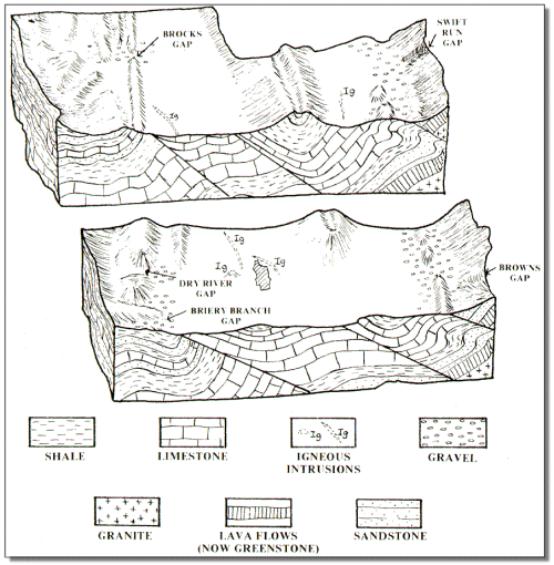
Figure 6. Major landforms and geology of Rockingham County today. Side views are provided along the southern edge and across the middle of the county to show rocks under the surface.
Figure 6 shows the relationship between today's landscape and the underlying geology. This relationship has evolved over the last 240 million years following the formation of the Appalachian Mountains. During this 240 million years, erosion has been the dominant geologic process at work on the Rockingham landscape. Even though this erosion is slow in human terms, over tens of millions of years it can drastically alter a mountain range or even wear it down to sea level. A look at the rocks making up Rockingham County today in Figure 6 indicates that thousands of feet of rock material have been eroded off and carried away by the rivers to the sea. So we know that our mountains of today such as the Blue Ridge, Massanutten and the Allegheny are mere stumps of former mountains which were originally much larger and more rugged. Areas underlain by hard resistant rocks like sandstone now stand as ridges while areas underlain by softer, less resistant rocks like limestone and shale now exist as valleys.

The most comprehensive study of the present landscape of Rockingham was made by geologist John Hack (1965) of the United States Geological Survey in his report on the geomorphology of the Shenandoah Valley. Hack theorized that the present ridges and valleys were related strongly to the resistance to erosion of the underlying bedrock. So areas with sandstone and greenstone bedrock have resisted erosion and now stand as ridges. Limestone being less resistant to erosion has worn down more rapidly and now forms the major portion of the lowland or valley floor. Hack calls this response a system of "dynamic equilibrium" indicating that erosion continues but the mountains and valleys retain their relative size and position.

Also of interest in Figure 6 are extensive gravel deposits which exist along the edge of the Blue Ridge and Allegheny Mountains. The most extensive of these deposits have been washed out of the Blue Ridge by stream action and have accumulated as thick aprons of loose sand and gravel which become thinner westward, away from the Blue Ridge. Most of the gravel is composed of rounded pieces of hard rock known as quartzite. Rounded pieces of this tan and yellow gravel can easily be seen by even a casual observer in the fields and roadcuts along Highway 340 and nearby secondary roads and along Fulks Run and Briery Branch in the western portion of the county.

The South Fork of the Shenandoah has reworked many of these gravels as it meandered back and forth across its valley through time. This action has resulted in the formation of a series of flat surfaces much like broad stair steps; these flat valley surfaces are called terraces. At many points in the vicinity of Elkton and along Route 340 one can notice the existence of these terraces. In some cases it is possible to look across the river and see a flat area of the same elevations indicating that the gravel layer once extended straight across, but the river has now deepened its valley forming newer flat areas at a lower elevation. Arrow points and other evidence of Indian occupation are commonly found on these terraces.

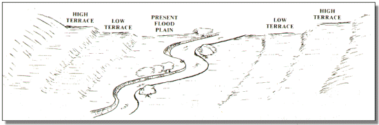
Figure 7. Terraces, like stair steps, represent former floodplains of the River. The river has been cut progressively downward from the high terrace to the low terrace to its present floodplain. Evidence of Indian occupancy is common on the terraces throughout Rockingham County. Portions of present day Elkton, Grottoes, Bridgewater, Broadway and Timberville are also located on terraces.

Finally, most of the rivers and streams in the county have developed active flood plains of various widths. Flood plains are the flat areas along streams covered by sand and silt deposited when the river is at flood stage. The flood plain often covers hundreds of acres and may cover the bedrock to a depth of several feet or even tens of feet. Flood plains usually make excellent farmland due to the fertile soil and moist conditions. However, building and development in the flood plain is risky and is usually not recommended due to the risk of periodic flooding during high rainfall periods. Figure 7 shows the present flood plain and terraces formed by a river.

[Main]  [Caves and Caverns]  [Geology and Human History in Rockingham]