INTRODUCTION
GEOLOGIC EVIDENCE FOR OCEANIC CONVERGENCE AND SUBDUCTION
There are certain geologic events and features that occur in association with plate convergence and subduction. These features are evident in various parts of the Appalachian Mountain system: the Piedmont, Blue Ridge, Valley and Ridge, and Plateau. The discussion below focuses on all the evidence, even though this trip visits stops only in the Valley and Ridge.
Plutons, Volcanics, and Bentonites
Probably the most noticeable effects of plate convergence are the various igneous features resulting from the melting of the subducting oceanic lithosphere (Figure 2). Today, volcanic arcs line one side of almost all ocean trenches. On the surface of these arcs, the thick piles of volcanic strata certainly provide testimony to the prolonged history of volcanism associated with these arcs. Such volcanic strata is present in the Virginia Piedmont in such units as the Chopawamsic/Arvonia volcanic suites just west of Fredericksburg, Virginia.
Although not apparent on the surface of a volcanic arc, plutons are present deep below the surface. These features become apparent when one investigates ancient volcanic arcs that have been eroded deeply enough to expose their cores. In such terrains, granites, diorites, and various other plutonic rocks exist as batholiths. Well known examples include the Sierra Nevada, Stone Mountain, and more locally the Petersburg and Occoquan Granites of the Virginia Piedmont. Ages of the plutonic rocks of the Virginia Piedmont cluster into a few time intervals: Cambrian, Silurian-Devonian, and Pennsylvanian-Permian (Wright and others, 1975). This suggests that plutonism in the Piedmont was sporadic during the Paleozoic.
Eruptions associated with volcanic arcs are typically explosive, as was the case for Mt. St. Helens, Pinatubo, Vesuvius, Paricutin, Katmai, Krakatoa, and so many others. Ash from these types of eruptions can be carried by the wind for long distances. The dust from Pinatubo reached such heights that atmospheric circulation carried it around the world. In some places, up to a distance of a thousand kilometers or two from the volcano, thin layers of ash are detected.
In the Paleozoic strata of the Valley and Ridge, thin, and frequently almost unnoticeable layers of volcanic ash, called bentonites, are found (Stop 3). These document the existence of a volcanic arc. The stratigraphic position of these Appalachian bentonites are Middle Ordovician and Middle Devonian.
Lithospheric Flexure
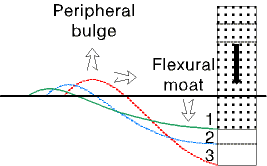 Subduction involves the thrusting of one plate margin over another. The subducting slab therefore is loaded with the mass of the overriding plate. This load is responsible, at least in part, for the subsidence of the subducting slab, and accounts, at least in part, for the bathymetric feature known as a trench. Other loads, such as the volcanic arc itself, or the accretionary prism (melange belt under the outer arc ridge in Figure 2) of sediment scraped off the subducting plate, are also responsible for this subsidence. Geophysicists have predicted (Beaumont and others, 1988, for example) that the depression of the crust adjacent to the overthrust load (flexural moat) is accompanied by an adjacent peripheral bulge (Figure 3) for much the same reason as if you stepped into the front of a canoe, the back of the canoe would rise. According to these models, it is also predicted that the flexural rigidity of the lithosphere lessens with time after the initial loading, causing the peripheral bulge to migrate toward the flexural moat and overthrust load (Figure 3).
Models of lithospheric flexure have been applied to the stratigraphy of the Appalachians, as well as other mountain belts, in an attempt to reconstruct the flexural moat and peripheral bulges associated with these ancient convergence events. To do so, individual episodes of shallowing (peripheral bulge), must be identified in the stratigraphic record. It is important to realize that these strata have subsequently been structurally deformed by later orogenic events and we cannot necessarily distinguish features formed by lithospheric flexure from those due to later structural deformation. We must therefore depend on the stratigraphy to tell us what structural events happened in the past. One must also realize that these areas of deepening and shallowing must have formed at the same time, but in different places. It is sometimes difficult to differentiate relative changes in sea-level due to lithospheric flexure from those due to global sea-level change. For example, the sea-level drop that resulted in the widespread unconformity at the top of the Beekmantown (Knox unconformity) has been interpreted as being due to worldwide lowering of sea-level (Vail and other, 1977), and alternatively being due to uplift of a peripheral bulge (Mussman and Read, 1986).
Models for different stages of lithospheric flexure in the Appalachians are varied. Beaumont and others (1988) propose that the entire Appalachian basin area was a flexure moat, and the Cincinnati Arch/Nashville dome was part of the peripheral bulge. On this trip we will see evidence suggesting that in the Ordovician, these features were much more localized, and probably existed within the area of the Valley and Ridge Province.
Flexure of the lithosphere in the Appalachian area probably occurred sporadically during the Paleozoic. Ettensohn (1987,1991) has proposed that episodes of flexure occurred during the Ordovician and again during the Devonian in the Appalachians.
Controls on Carbonate Deposition
In tropical shallow marine areas today, sedimentation can be considered under two categories: that influences by river runoff, and that which is not. In the absence of rivers, as is the case on the Bahama banks today, tropical shallow marine waters typically have just the right combination of factors that favor the precipitation of calcium carbonate as limestone.
Precipitation of a compound occurs as its solubility decreases. Calcium carbonate is less soluble under high pH (alkaline) conditions. Normal seawater is slightly alkaline, and very close to the critical pH that controls the saturation point of seawater relative to calcium carbonate. Small changes in pH are all it takes to drastically alter the solubility of calcium carbonate.
Sea water pH is controlled by the amount of dissolved carbon dioxide. If the carbon dioxide declines, carbonic acidity decreases and carbonate precipitation occurs. Each of the following conditions favors the removal or escape of carbon dioxide: higher temperature; agitation of the water by waves; and photosynthesis by marine plants. It is observed that limestone forms most prominently in warm (tropical), shallow, agitated, algal rich seawater. The Appalachian area during the Paleozoic was in this default condition.
The default condition would not hold under different circumstances. For example, in tropical areas today, limestone is not actively forming in deep water, presumably due to the lack of agitation by waves, the lack of sunlight allowing photosynthesis, and the cooler water temperature at depth.
Another example of a situation where the default condition does not hold is coastlines receiving significant river runoff. Rivers typically contribute lower pH (if not acidic) water, which raises the solubility of calcium carbonate, and retards or prevents the formation of limestone. In addition, rivers carry siliciclastic sediment (gravel, sand, silt, clay). Clastics and carbonate therefore tend to be mutually exclusive (Walker and others, 1983).
Clastic Wedges
The above explanation of carbonates emphasizes the significance of the Appalachian clastic wedges. A clastic wedge is a thick (up to several kilometers), widespread (more than a million square kilometers), fan-shaped, wedge of clastic strata. These clastic wedges commonly, but not always, fill flexural moats created by lithospheric flexure. Flexural moats developed when one plate overrides another are often called foreland basins (see Figure 4). The overriding plate is a hinterland. In the Appalachians of the Paleozoic several clastic wedges alternate with carbonate sequences through time. These clastic wedges represent times and places when the normal default conditions (limestones) were overridden, and rivers carried clastic sediments into the Appalachian area. Clastic wedges of Ordovician, Devonian, and Mississippian-Pennsylvanian age occur in the Appalachians (Figure 1).
Thickness patterns and paleocurrents indicate that the clastic wedges were derived from the east, and not from the North American craton to the west. Each clastic wedge contains a generally coarsening-and-shallowing-upward stratigraphic succession. This is consistent with the progradation of a clastic shoreline into a marine basin. The clastic material suggests that it was derived from continental and/or volcanic source areas. In fact, volcanic bentonites are associated with strata just below, or in the lower parts of Ordovician and Devonian clastic wedges. Therefore volcanic arc, or volcanic arcs associated with continental blocks now found in the Piedmont are the likely sources of the clastic wedges.
Structural Deformation and Metamorphism
Structural deformation, in the form of folding and thrust faulting, is a process associated with subduction and mountain building (Figure 4). The structural deformation has involved the Valley and Ridge, Blue Ridge, and Piedmont Provinces. As illustrated in the geologic map (Figure 5), the structural deformation of the Valley and Ridge has involved strata of Cambrian to Mississippian age. This relationship indicates that this deformation occurred after the deposition of these strata. This late stage of deformation occurring after the Mississippian is the Alleghenian Orogeny. It was responsible for the majority of structures in the Valley and Ridge.
The severity of the Alleghenian deformation has overprinted older deformational features, making these older features much harder to recognize. As discussed above, lithospheric flexure deformation did occur earlier in the Paleozoic, during deposition of the Valley and Ridge strata. This pre-Alleghenian deformation occurred as basins (flexure moats) and uplifts (peripheral bulges). These basins and uplifts are now recognized in the stratigraphic record, not necessarily as deformational structures, but as changes in thickness and other characteristics of the strata. These stratigraphic features are discussed in the stop descriptions.
Metamorphism can be considered another type of deformational event associated with subduction and mountain building (Figures 2 and 4). Paleozoic metamorphism has affected the Piedmont and Blue Ridge Provinces. Metamorphic ages, determined for rocks of the Piedmont and Blue Ridge, indicate tow distinct events: a high-grade metamorphic event during the Ordovician and a low-grade event during the Devonian (Hatcher, 1978). Generally speaking, there is a temporal and spatial coincidence between metamorphic events, lithospheric flexure, and deposition of clastic wedges.